IMAGES TAKEN NEAR TO
Penbidwal Lane, ABERGAVENNY, NP7 8EA
Introduction
This page details the photographs taken nearby to Penbidwal Lane, NP7 8EA by members of the Geograph project.
The Geograph project started in 2005 with the aim of publishing, organising and preserving representative images for every square kilometre of Great Britain, Ireland and the Isle of Man.

There are currently over 7.5m images from over14,400 individuals and you can help contribute to the project by visiting https://www.geograph.org.uk
Image Map
Images are licensed for reuse under creativecommons.org/licenses/by-sa/2.0
Notes
- Clicking on the map will re-center to the selected point.
- The higher the marker number, the further away the image location is from the centre of the postcode.
Image Listing (10 Images Found)
Images are licensed for reuse under creativecommons.org/licenses/by-sa/2.0
Image
Details
Distance

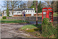
3
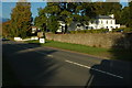
Park Hotel
The Park Hotel beside the A465 in Pandy.
Image: © Philip Halling
Taken: 16 Oct 2010
0.17 miles
4
Park Hotel, Pandy
Set back from the east side of the A465 in the small village of Pandy in Monmouthshire.
Image: © Jaggery
Taken: 19 Feb 2012
0.19 miles
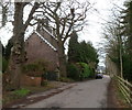
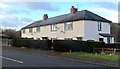
5
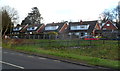
Glan Honddu Close houses, Pandy
Semi-detached houses set back from the east side of the A465.
Image: © Jaggery
Taken: 19 Feb 2012
0.20 miles
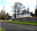
6
Park Hotel
Hotel on the A465 through Pandy, housed in a building named Glan-Honddu, marked on the 1886 6 inch map. Following recent closure, it is being converted to housing.
Image: © Ian Capper
Taken: 21 Feb 2022
0.20 miles
7
Mid-Victorian house, Pandy
The year 1872 is on the name sign for Brynhyfryd in Glan Honddu Close.
Image: © Jaggery
Taken: 19 Feb 2012
0.21 miles
8
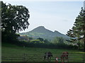
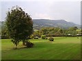
Ysgyryd Fawr / the Skirrid viewed from Pandy
The most photogenic angle of this mountain maybe, is gained from Pandy. The steep 'north face' can be appreciated, along with the landslip and the trig point on the summit.
Image: © Jeremy Bolwell
Taken: 1 Sep 2013
0.23 miles
9
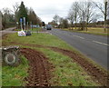
Tyres tracks alongside a Brecon Beacons National Park boundary marker in Pandy
Alongside the A465, the main road through Pandy.
Image: © Jaggery
Taken: 19 Feb 2012
0.24 miles
10
Glandwr Cottages, Pandy
A row of four houses alongside the A465, opposite the Park Hotel. http://www.geograph.org.uk/photo/3786431
Image: © Jaggery
Taken: 19 Feb 2012
0.24 miles