IMAGES TAKEN NEAR TO
Trehonddu, ABERGAVENNY, NP7 8DG
Introduction
This page details the photographs taken nearby to Trehonddu, NP7 8DG by members of the Geograph project.
The Geograph project started in 2005 with the aim of publishing, organising and preserving representative images for every square kilometre of Great Britain, Ireland and the Isle of Man.

There are currently over 7.5m images from over14,400 individuals and you can help contribute to the project by visiting https://www.geograph.org.uk
Image Map
Images are licensed for reuse under creativecommons.org/licenses/by-sa/2.0
Notes
- Clicking on the map will re-center to the selected point.
- The higher the marker number, the further away the image location is from the centre of the postcode.
Image Listing (85 Images Found)
Images are licensed for reuse under creativecommons.org/licenses/by-sa/2.0
Image
Details
Distance
1
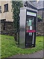
New use for a former BT phonebox, Llanvihangel Crucorney, Monmouthshire
In September 2024 a notice on the box shows AED Emergency defibrillator.
Image: © Jaggery
Taken: 22 Sep 2024
0.03 miles
2
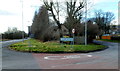
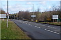
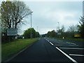
Llanvihangel Crucorney boundary sign
Llanvihangel Crucorney is a small village in northern Monmouthshire, 5 miles (8 km) north of Abergavenny and 18 miles (29 km) SW of Hereford. The A465 is on the left. The road through the village on the right used to be the route of the A465.
Image: © Jaggery
Taken: 19 Feb 2012
0.03 miles
3
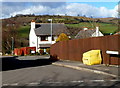
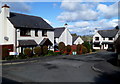
Trehonddu, Llanvihangel Crucorney
Looking towards Chapel Grove. http://www.geograph.org.uk/photo/3846191
Image: © Jaggery
Taken: 19 Feb 2012
0.03 miles
4
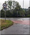
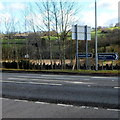
50 sign, Llanvihangel Crucorney, Monmouthshire
The 20mph speed limit increases to 50mph on the A465
Image: © Jaggery
Taken: 22 Sep 2024
0.03 miles
5

Two bus stops in Llanvihangel Crucorney
The bus stops are alongside the road through the small village of Llanvihangel Crucorney in north Monmouthshire. Through traffic can avoid this road by staying on the A465 which runs more or less parallel with this road, a few tens of metres to the SE.
Image: © Jaggery
Taken: 19 Feb 2012
0.04 miles
6
Llanvihangel Crucorney boundary signs
The A465 reaches Llanvihangel Crucorney, a small village in northern Monmouthshire,
5 miles (8 km) north of Abergavenny and 18 miles (29 km) SW of Hereford.
Image: © Jaggery
Taken: 19 Feb 2012
0.04 miles
7
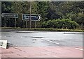
18 miles from Hereford
Located in the background here https://www.geograph.org.uk/photo/7886775 signs alongside the A465
in Llanvihangel Crucorney (Monmouthshire) show left for
Hereford (18 miles), right for Abergavenny (Y Fenni in Welsh) (5 miles).
Image: © Jaggery
Taken: 22 Sep 2024
0.04 miles
8
Distances from Llanvihangel Crucorney
Signs alongside the A465 show that the village in northern Monmouthshire
is 5 (miles) from Abergavenny and 18 from Hereford.
Image: © Jaggery
Taken: 19 Feb 2012
0.04 miles
9
Chapel Grove, Llanvihangel Crucorney
Viewed from Trehonddu. http://www.geograph.org.uk/photo/3846192
Image: © Jaggery
Taken: 19 Feb 2012
0.06 miles
10
Llanvihangel Crucorney village sign on A465
Image: © Colin Pyle
Taken: 7 May 2012
0.06 miles