IMAGES TAKEN NEAR TO
Triley, ABERGAVENNY, NP7 8DF
Introduction
This page details the photographs taken nearby to NP7 8DF by members of the Geograph project.
The Geograph project started in 2005 with the aim of publishing, organising and preserving representative images for every square kilometre of Great Britain, Ireland and the Isle of Man.

There are currently over 7.5m images from over14,400 individuals and you can help contribute to the project by visiting https://www.geograph.org.uk
Image Map
Images are licensed for reuse under creativecommons.org/licenses/by-sa/2.0
Notes
- Clicking on the map will re-center to the selected point.
- The higher the marker number, the further away the image location is from the centre of the postcode.
Image Listing (12 Images Found)
Images are licensed for reuse under creativecommons.org/licenses/by-sa/2.0
Image
Details
Distance
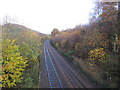
1
Looking back along towards Maerdy
Image: © Nick Mutton 01329 000000
Taken: 16 Sep 2007
0.02 miles
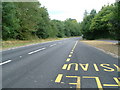
2
House and car, next to the A465, heading north
Image: © Rob Purvis
Taken: 4 Nov 2017
0.02 miles
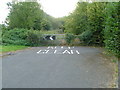
5
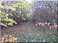
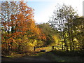
The old road, near Great Triley
A section of disused road lies beneath the leaves near Great Triley. The course of the new A465 is to the right.
Image: © Gareth James
Taken: 19 Nov 2016
0.11 miles
6
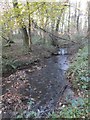
Gavenny within Great Triley Wood
The Woodland Trust own this woodland but due to poor access to it and damp access within it, don't particularly promote it to the public. The small River Gavenny floods across much of the woodland floor each winter. A circular path around the wood fords the water at this point.
Image: © Alan Bowring
Taken: 30 Nov 2013
0.12 miles
7
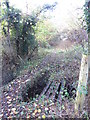
Bridge across a stream in Great Triley Wood
Image: © Gareth James
Taken: 19 Nov 2016
0.17 miles
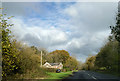
9
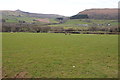
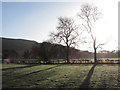
Farmland between Ysgyryd Fawr and the Black Mountains
View across the valley towards Sugar Loaf, the summit of which is just visible. The A465 passes through this valley.
Image: © Philip Halling
Taken: 15 Mar 2014
0.20 miles