IMAGES TAKEN NEAR TO
Llanddewi Rhydderch, ABERGAVENNY, NP7 8BP
Introduction
This page details the photographs taken nearby to NP7 8BP by members of the Geograph project.
The Geograph project started in 2005 with the aim of publishing, organising and preserving representative images for every square kilometre of Great Britain, Ireland and the Isle of Man.

There are currently over 7.5m images from over14,400 individuals and you can help contribute to the project by visiting https://www.geograph.org.uk
Image Map
Images are licensed for reuse under creativecommons.org/licenses/by-sa/2.0
Notes
- Clicking on the map will re-center to the selected point.
- The higher the marker number, the further away the image location is from the centre of the postcode.
Image Listing (28 Images Found)
Images are licensed for reuse under creativecommons.org/licenses/by-sa/2.0
Image
Details
Distance
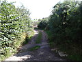
1
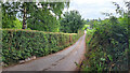
Narrow lane
Emmasfield Farm is by the bend at the bottom of the road.
Image: © Jonathan Billinger
Taken: 5 Jul 2022
0.03 miles
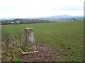
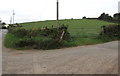
3
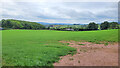
Grassland at The Tump
The view south-west towards Mynachdy Farm
Image: © Jonathan Billinger
Taken: 5 Jul 2022
0.05 miles
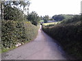
4
Lane near Emmasfield Farm, Monmouthshire
Viewed across the B4233 Mynachdy Pitch in September 2020.
An Emmasfield Farm building https://www.geograph.org.uk/photo/6614091 is on the right.
Image: © Jaggery
Taken: 20 Sep 2020
0.12 miles
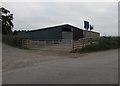
6
Farm building near the B4233 in rural Monmouthshire
Set back from the north side of the B4233 (here named Mynachdy Pitch)
This https://www.geograph.org.uk/photo/7848384 Parc Gwyn Farm name sign is near the camera.
Image: © Jaggery
Taken: 11 Aug 2024
0.13 miles
7
Emmasfield Farm building near Llanddewi Rhydderch, Monmouthshire
Viewed across the B4233 Mynachdy Pitch in September 2020.
Image: © Jaggery
Taken: 20 Sep 2020
0.13 miles
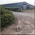
9
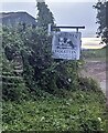
Holstein on a farm name sign in rural Monmouthshire
In August 2024 the text below a depiction of a cow on the sign alongside the B4233 is
HOLSTEIN
TG & DA JONES & SONS
PARC GWYN FARM
Image: © Jaggery
Taken: 11 Aug 2024
0.14 miles
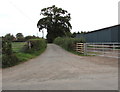
10
Field gate, Emmasfield Farm, Monmouthshire
On the left here https://www.geograph.org.uk/photo/6614104 viewed from the B4233 Mynachdy Pitch in September 2020.
Image: © Jaggery
Taken: 20 Sep 2020
0.14 miles