IMAGES TAKEN NEAR TO
Town Farm Meadow, ABERGAVENNY, NP7 8AF
Introduction
This page details the photographs taken nearby to Town Farm Meadow, NP7 8AF by members of the Geograph project.
The Geograph project started in 2005 with the aim of publishing, organising and preserving representative images for every square kilometre of Great Britain, Ireland and the Isle of Man.

There are currently over 7.5m images from over14,400 individuals and you can help contribute to the project by visiting https://www.geograph.org.uk
Image Map
Images are licensed for reuse under creativecommons.org/licenses/by-sa/2.0
Notes
- Clicking on the map will re-center to the selected point.
- The higher the marker number, the further away the image location is from the centre of the postcode.
Image Listing (214 Images Found)
Images are licensed for reuse under creativecommons.org/licenses/by-sa/2.0
Image
Details
Distance
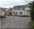
1
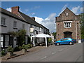
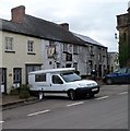
The Angel Inn, Grosmont
The Angel Inn in the village of Grosmont.
Image: © Philip Halling
Taken: 30 Jul 2006
0.02 miles
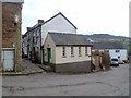
2
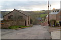
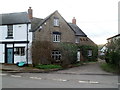
Town Farm Barn and Town Barn, Grosmont
Town Farm Barn is on the right; Town Barn is on the left.
Image: © Jaggery
Taken: 19 Feb 2012
0.02 miles
3
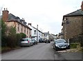
Looking north along the main road through Grosmont
Looking towards Kentchurch from near the Poorscript Lane junction. http://www.geograph.org.uk/photo/2812407
Grade II* listed Glyndŵr http://www.geograph.org.uk/photo/2812626 is on the left.
Rock Villa http://www.geograph.org.uk/photo/2812341 is on the right.
Image: © Jaggery
Taken: 19 Feb 2012
0.05 miles
4
Eastern end of Poorscript Lane, Grosmont
The unusual name sounds like a reason for the rejection of a television programme, but the lane was probably named in the Middle Ages. It appears to be the only Poorscript Lane in the UK.
Image: © Jaggery
Taken: 19 Feb 2012
0.05 miles
5
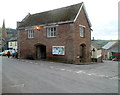
Grade II listed Grosmont Town Hall
It may seem incongruous that the village of Grosmont, population about 300, has a town hall.
The original town hall was a timber structure built in the Middle Ages when Grosmont was reputed to have been for a time the third-largest settlement in South Wales. The present town hall dates from the 1830s, at a time when Grosmont still had a mayor. It is now used by Grosmont Community Council which covers a large area of thinly-populated North East Monmouthshire. There are four council wards, Grosmont, Llangua, Llangattock Lingoed and Llanvetherine, with a total population of c600.
The town hall was Grade II listed in March 1981.
Image: © Jaggery
Taken: 19 Feb 2012
0.05 miles
6
Grade II listed York House, Grosmont
The large house, formerly The Duke of York Inn, was Grade II listed in October 2000.
Image: © Jaggery
Taken: 19 Feb 2012
0.05 miles
7
Grosmont public toilets
Grosmont has well-maintained public toilets, and open on a Sunday. The entrance for males is via the green doors on the left. The entrance for females is on the right side of the building. The building behind the toilets is the village pub. http://www.geograph.org.uk/photo/2813001
Image: © Jaggery
Taken: 19 Feb 2012
0.05 miles
8
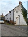
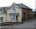
Grade II* listed Town Farm farmhouse, Grosmont
The late 17th century building was Grade II* listed in September 1956.
Image: © Jaggery
Taken: 19 Feb 2012
0.05 miles
9
Grade II listed Angel Inn, Grosmont
The only remaining pub in the village was saved from closure when it was bought by a consortium of local residents in 2005. Dating from the 17th century, the inn was extensively altered in the 19th century. Grade II listed in October 2000.
Image: © Jaggery
Taken: 19 Feb 2012
0.05 miles
10
Grade II listed The Old Greyhound, Grosmont
The house was formerly The Old Greyhound Inn, dating from the 17th century.
Converted to a house in the early 1920s. Grade II listed in October 2000.
Image: © Jaggery
Taken: 19 Feb 2012
0.05 miles