IMAGES TAKEN NEAR TO
Pandy, ABERGAVENNY, NP7 7PB
Introduction
This page details the photographs taken nearby to NP7 7PB by members of the Geograph project.
The Geograph project started in 2005 with the aim of publishing, organising and preserving representative images for every square kilometre of Great Britain, Ireland and the Isle of Man.

There are currently over 7.5m images from over14,400 individuals and you can help contribute to the project by visiting https://www.geograph.org.uk
Image Map
Images are licensed for reuse under creativecommons.org/licenses/by-sa/2.0
Notes
- Clicking on the map will re-center to the selected point.
- The higher the marker number, the further away the image location is from the centre of the postcode.
Image Listing (49 Images Found)
Images are licensed for reuse under creativecommons.org/licenses/by-sa/2.0
Image
Details
Distance
1
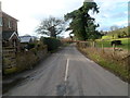
Minor road from Pandy to Llanthony
Viewed from this http://www.geograph.org.uk/photo/3786824 junction in rural north Monmouthshire.
Image: © Jaggery
Taken: 19 Feb 2012
0.02 miles
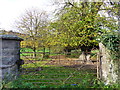
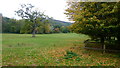
2
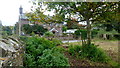
Trewyn Lodge
Viewed from just inside the field on a public footpath.
How many nettle-infested corners like this are there in this great country of ours?
Image: © Jonathan Billinger
Taken: 17 Oct 2015
0.08 miles
3
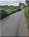
Towards Trewyn Lodge, Pandy, Monmouthshire
Looking towards this https://www.geograph.org.uk/photo/7186465 house opposite a junction.
Image: © Jaggery
Taken: 29 May 2022
0.09 miles
4
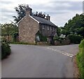
Stone house opposite a junction, Pandy, Monmouthshire
Take the left fork past Trewyn Lodge for the A465.
Take the right fork for Cwmyoy and Llanthony.
Behind the camera for Walterstone, Clodock and Longtown.
Image: © Jaggery
Taken: 29 May 2022
0.09 miles
5
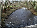
Afon Honddu upstream, Pandy
A tributary of the Monnow, the Afon Honddu here marks the eastern boundary of the Brecon Beacons National Park, which is on the right side of the river. Viewed from this http://www.geograph.org.uk/photo/3786793 bridge.
Image: © Jaggery
Taken: 19 Feb 2012
0.09 miles
7
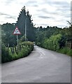
Low headroom warning sign, Pandy
The sign showing headroom 4 metres / 13' 1" is on the approach to this https://www.geograph.org.uk/photo/2116491 railway bridge.
Image: © Jaggery
Taken: 29 May 2022
0.09 miles
8
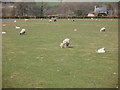
Pandy, sheep
Ewes and lambs near Trewyn Lodge.
Image: © Mike Faherty
Taken: 9 Apr 2010
0.09 miles
9
Line of a footpath
Heading north-west from Trewyn Lodge.
The hill beyond is Pentwyn hillfort and is at the southern tip of the Hatterrall Ridge which forms the English/Welsh border from Pandy to Hay Bluff.
Image: © Jonathan Billinger
Taken: 17 Oct 2015
0.09 miles
10
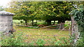
Old iron gate
Suggestive of the park-like appearance of the field opposite Trewyn Lodge.
See also Image showing Geographers' minds tend to think alike.
Image: © Jonathan Billinger
Taken: 17 Oct 2015
0.10 miles