IMAGES TAKEN NEAR TO
Cwmyoy, ABERGAVENNY, NP7 7PA
Introduction
This page details the photographs taken nearby to NP7 7PA by members of the Geograph project.
The Geograph project started in 2005 with the aim of publishing, organising and preserving representative images for every square kilometre of Great Britain, Ireland and the Isle of Man.

There are currently over 7.5m images from over14,400 individuals and you can help contribute to the project by visiting https://www.geograph.org.uk
Image Map
Images are licensed for reuse under creativecommons.org/licenses/by-sa/2.0
Notes
- Clicking on the map will re-center to the selected point.
- The higher the marker number, the further away the image location is from the centre of the postcode.
Image Listing (8 Images Found)
Images are licensed for reuse under creativecommons.org/licenses/by-sa/2.0
Image
Details
Distance
1
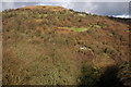
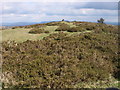
Twyn y Gaer
Twyn y Gaer is a hill fort in the Black Mountains. Here it is viewed across Cwm Coed-y-cerrig from the northern slopes of Bryn Arw. Gaer Farm can be seen just below the summit to the right.
Image: © Philip Halling
Taken: 25 Feb 2007
0.12 miles
2
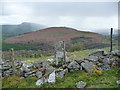
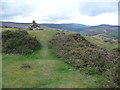
On Twyn y Gaer
The Holy Mountain, Ysgyryd Fawr (Skirrid Fawr) at Abergavenny is vanishing behind the veil of an April shower, leaving Bryn Arw looking shapely. Viewed over an old boundary wall near the edge of the Iron Age hillfort of Twyn y Gaer.
Image: © Jeremy Bolwell
Taken: 21 Apr 2012
0.16 miles
3
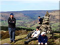
Twyn y Gaer
Cerddwyr yn cael seibiant o fewn Twyn y Gaer, bryngaer o'r Oes Haearn. Mae golygfeydd o'r lle hwn yn ardderchog. Yn y pellter gwelir Cwm Euas.
Walkers having a break inside Twyn y Gaer (hill of the fort), an Iron Age monument. The views from this location are splendid. In the distance is the Vale of Ewyas.
Image: © Alan Richards
Taken: 11 Apr 2010
0.22 miles
4
Gaer hill and the Skirrid from Crug Mawr
Image: © James Ayres
Taken: 24 Mar 2008
0.22 miles
5
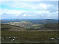
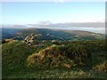
Summit cairn on Gaer
A relatively low hill but one that affords splendid panoramic views to each of its neighbours - no doubt a factor in the decision by its Iron Age occupants to site their defensive works here.
Image: © Alan Bowring
Taken: 5 Apr 2008
0.24 miles
6
On Twyn y Gaer in the Black Mountains
A stone cairn has been built on the high point of the hillfort.
Image: © Jeremy Bolwell
Taken: 21 Apr 2012
0.24 miles
8
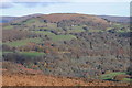
Gaer viewed from across the valley
Gaer viewed from across the valley which the hamlet of Forest Coal Pit is situated
Image: © Philip Halling
Taken: 23 Nov 2013
0.25 miles