IMAGES TAKEN NEAR TO
Llanthony, ABERGAVENNY, NP7 7NL
Introduction
This page details the photographs taken nearby to NP7 7NL by members of the Geograph project.
The Geograph project started in 2005 with the aim of publishing, organising and preserving representative images for every square kilometre of Great Britain, Ireland and the Isle of Man.

There are currently over 7.5m images from over14,400 individuals and you can help contribute to the project by visiting https://www.geograph.org.uk
Image Map
Images are licensed for reuse under creativecommons.org/licenses/by-sa/2.0
Notes
- Clicking on the map will re-center to the selected point.
- The higher the marker number, the further away the image location is from the centre of the postcode.
Image Listing (17 Images Found)
Images are licensed for reuse under creativecommons.org/licenses/by-sa/2.0
Image
Details
Distance
1
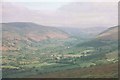
The Vale of Ewyas
This outstandingly beautiful valley runs a deep trench through the Black Mountains.
Image: © Jonathan Billinger
Taken: 23 May 1998
0.06 miles
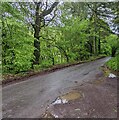
2
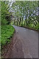
Unclassified road towards Llanthony, Monmouthshire
Looking to the NW along the road from Llanvihangel Crucorney to Hay-on-Wye. A Llanthony Wood nameboard https://www.geograph.org.uk/photo/7174234 is behind the camera.
Image: © Jaggery
Taken: 15 May 2022
0.06 miles
3
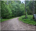
Into Llanthony Wood, Monmouthshire
Into the east side of the wood from the unclassified road from Llanvihangel Crucorney to Hay-on-Wye. A Llanthony Wood nameboard https://www.geograph.org.uk/photo/7174234 is on the right. Notices alongside the woodland access road show "No entry to unauthorised vehicles".
Image: © Jaggery
Taken: 15 May 2022
0.08 miles
4
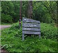
Llanthony Wood nameboard, Monmouthshire
The Natural Resources Wales board faces the unclassified road from Llanvihangel Crucorney to Hay-on-Wye via Llanthony. Text on the board in May 2022 includes "BRECON BEACONS NATIONAL PARK" and the Welsh "Coed Llanthony" and "Coed Graig Ddu".
Image: © Jaggery
Taken: 15 May 2022
0.09 miles
5
Unclassified road from Llanthony towards Llanvihangel Crucorney
In rural Monmouthshire. A Llanthony Wood nameboard https://www.geograph.org.uk/photo/7174234 is near the camera.
Image: © Jaggery
Taken: 15 May 2022
0.12 miles
6
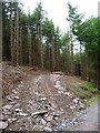
Felling operations in Llanthony Wood
A new road for heavy machinery on the west side of the restricted byway.
Image: © Christine Johnstone
Taken: 30 May 2017
0.15 miles
7
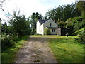
Graig-ddu
A lovely rural property in woodland in the Llanthony Valley.
Image: © Jeremy Bolwell
Taken: 8 Sep 2012
0.18 miles
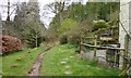
9
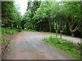
Track junction, northern end of Llanthony Wood
The forestry vehicles take the sharp bend, but the restricted byway continues straight ahead.
Image: © Christine Johnstone
Taken: 30 May 2017
0.19 miles
10
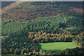
Above the Vale of Ewyas
Upland, woodland and a field on the western slopes of the Vale of Ewyas to the south of Llanthony Priory, viewed from the Hatterrall Ridge.
Image: © Philip Halling
Taken: 16 Oct 2010
0.21 miles