IMAGES TAKEN NEAR TO
Cwmyoy, ABERGAVENNY, NP7 7NE
Introduction
This page details the photographs taken nearby to NP7 7NE by members of the Geograph project.
The Geograph project started in 2005 with the aim of publishing, organising and preserving representative images for every square kilometre of Great Britain, Ireland and the Isle of Man.

There are currently over 7.5m images from over14,400 individuals and you can help contribute to the project by visiting https://www.geograph.org.uk
Image Map
Images are licensed for reuse under creativecommons.org/licenses/by-sa/2.0
Notes
- Clicking on the map will re-center to the selected point.
- The higher the marker number, the further away the image location is from the centre of the postcode.
Image Listing (43 Images Found)
Images are licensed for reuse under creativecommons.org/licenses/by-sa/2.0
Image
Details
Distance
1
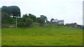
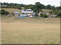
Llwyncelyn
A hillside location for this farm overlooking the southern end of the Ewyas Valley.
Image: © Jonathan Billinger
Taken: 7 Jun 2016
0.01 miles
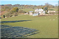
2
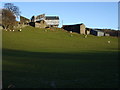
Llwyncelyn
At the time of this photograph this farm in a valley below the Black Mountains is undergoing building work. Pevsner describes it as 'a fine farm group as seen from the south, the gable-end of a barn below, the farmhouse above.' He also states that 'the house is something quite exceptional, a complete late medieval hall house, with a parlour wing, all of stone.'
Image: © Philip Halling
Taken: 9 Dec 2006
0.01 miles
3
Llwyncelyn
I have photographed this farm just off the Vale of Ewyas before and each time part of it is shrowded from view. Pevsner describes it as 'a fine farm group as seen from the south, the gable-end of a barn below, the farmhouse above.' He also states that 'the house is something quite exceptional, a complete late medieval hall house, with a parlour wing, all of stone.'
Image: © Philip Halling
Taken: 26 May 2012
0.01 miles
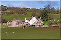
4
Llewyncelyn, Stanton
The white building is Llewyn-celyn Farmhouse, a rare surviving medieval hall with mostly C17 additions.
Image: © M J Roscoe
Taken: 2 Feb 2022
0.02 miles
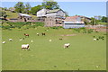
5
Llwyncelyn
Farm just off the Honddu valley below the Black Mountains. Pevsner describes it as 'a fine farm group as seen from the south, the gable-end of a barn below, the farmhouse above.' He also states that 'the house is something quite exceptional, a complete late medieval hall house, with a parlour wing, all of stone.'
Image: © Philip Halling
Taken: 6 Aug 2006
0.02 miles
6
Llwyncelyn
I have photographed Llwyncelyn a number of times and each time the building is under protective sheeting. Image] Image] Image]
Image: © Philip Halling
Taken: 23 Nov 2013
0.06 miles
7
Towards Llwyn Celyn
Looking towards Llwyn Celyn from by Brynarw.
Image: © Ian Capper
Taken: 25 Feb 2022
0.08 miles
8
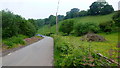
Road to Partrishow
An unofficial walker's car park up ahead.
Image: © Jonathan Billinger
Taken: 7 Jun 2016
0.09 miles
9
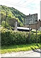
Direction and distances sign, Stanton, Monmouthshire
Ahead for Llanvihangel (1¼ (miles)) and Abergavenny (6).
Right for Forest Coal Pit (2), Partrishow (3), Llanbedr (5).
Image: © Jaggery
Taken: 15 May 2022
0.11 miles
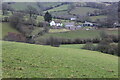
10
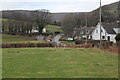
Stanton hamlet
A small hamlet on the road to the Vale of Eywas. The hedge, mid picture, is on the minor road to Llanbedr. The distant white building behind trees is Llwyncelyn Farm.
Image: © M J Roscoe
Taken: 2 Feb 2022
0.12 miles