IMAGES TAKEN NEAR TO
Old Hereford Road, ABERGAVENNY, NP7 7LJ
Introduction
This page details the photographs taken nearby to Old Hereford Road, NP7 7LJ by members of the Geograph project.
The Geograph project started in 2005 with the aim of publishing, organising and preserving representative images for every square kilometre of Great Britain, Ireland and the Isle of Man.

There are currently over 7.5m images from over14,400 individuals and you can help contribute to the project by visiting https://www.geograph.org.uk
Image Map
Images are licensed for reuse under creativecommons.org/licenses/by-sa/2.0
Notes
- Clicking on the map will re-center to the selected point.
- The higher the marker number, the further away the image location is from the centre of the postcode.
Image Listing (6 Images Found)
Images are licensed for reuse under creativecommons.org/licenses/by-sa/2.0
Image
Details
Distance
1
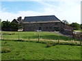
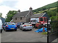
New build at Penyclawdd
At first I thought it was a barn conversion but I think it is a new build, designed to look old.
Image: © Jeremy Bolwell
Taken: 1 Sep 2013
0.03 miles
2
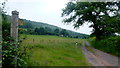
Track and footpath to Penyclawdd
The path continues to access Bryn Arw to the left of shot.
Image: © Jonathan Billinger
Taken: 7 Jun 2016
0.17 miles
3
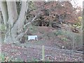
Source of the River Gavenny
Dimly lit after the sun had set at the end of this late November day, this view from the public footpath down into a former quarry on the edge of Coed Pen-y-clawdd reveals a rivulet which is the infant Gavenny (Afon Gafenni).
Image: © Alan Bowring
Taken: 30 Nov 2013
0.19 miles
4
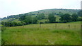
View to the eastern flank of Bryn Arw
From the bend in the Old Hereford Road.
Image: © Jonathan Billinger
Taken: 7 Jun 2016
0.20 miles
6
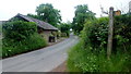
The Old Hereford Road
Looking south towards Abergavenny at the Penyclawdd bend.
Image: © Jonathan Billinger
Taken: 7 Jun 2016
0.22 miles