IMAGES TAKEN NEAR TO
Llwyn Du, ABERGAVENNY, NP7 7HU
Introduction
This page details the photographs taken nearby to NP7 7HU by members of the Geograph project.
The Geograph project started in 2005 with the aim of publishing, organising and preserving representative images for every square kilometre of Great Britain, Ireland and the Isle of Man.

There are currently over 7.5m images from over14,400 individuals and you can help contribute to the project by visiting https://www.geograph.org.uk
Image Map
Images are licensed for reuse under creativecommons.org/licenses/by-sa/2.0
Notes
- Clicking on the map will re-center to the selected point.
- The higher the marker number, the further away the image location is from the centre of the postcode.
Image Listing (20 Images Found)
Images are licensed for reuse under creativecommons.org/licenses/by-sa/2.0
Image
Details
Distance
1
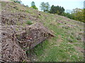
Remnant of a ruined house on the Rholben
At some stage in Victorian times someone decided to build a house up here, possibly a hunting lodge or property associated with shooting, gamekeeping or the management of an estate encompassing the hillsides and mountains. It only has small wall remnants remaining, along with the faint layout of a garden and property boundaries.
Image: © Jeremy Bolwell
Taken: 21 May 2012
0.08 miles
2
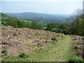
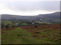
Path on the Rholben with views down to Abergavenny
A popular route up and down the mountain.
Image: © Jeremy Bolwell
Taken: 29 Jul 2012
0.09 miles
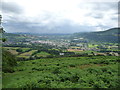
3
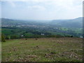
View southwards from the front of the Rholben
Abergavenny town lies out below in the valley of the River Usk, with Nevil Hall hospital prominent on the western fringe of the town. The Blorenge provides the backdrop and a haze obscures the valley of the Usk towards Llanellen and Llanover.
Image: © Jeremy Bolwell
Taken: 21 May 2012
0.10 miles
4
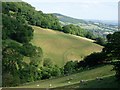
Sheep and sheep tracks
Looking across the steep valley from the car park
Image: © Hugh Venables
Taken: 11 Jul 2006
0.10 miles
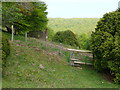
5
Old iron bench on the Rholben
A feature that has survived up here for years, as long as I can remember anyway. People do use it I believe. It gets overgrown with last summers bracken, which can grow very tall on this spot.
Image: © Jeremy Bolwell
Taken: 21 May 2012
0.10 miles
6
Path up the Rholben in May
With a decent view of Abergavenny laid out below. The 'new look' Little Skirrid / Ysgyryd Fach shorn of its forestry looks great.
Image: © Jeremy Bolwell
Taken: 21 May 2012
0.11 miles
7
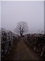
Tree by Car Park - Porth y Parc.
This tree, which provides a landmark for those descending the Sugar Loaf wondering how far it is to the car, stands out well on this bitterly cold morning.
Image: © Frank Cook
Taken: 1 Jan 2009
0.11 miles
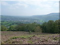
8
View southwards off the Rholben
Abergavenny can be seen in its wonderful location in the Usk Valley.
Image: © Jeremy Bolwell
Taken: 21 May 2012
0.12 miles
9
View down on Abergavenny from the Rholben in winter
A winter squall passes down the Usk valley towards Llanover. Nevill Hall Hospital stands out on the western fringe of town.
Image: © Jeremy Bolwell
Taken: 27 Dec 2013
0.13 miles
10
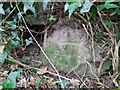
Ordnance Survey Cut Mark
This badly eroded OS cut mark can be found on the wall east side of the road. It marks a point 234.316m above mean sea level.
Image: © Adrian Dust
Taken: 21 Aug 2023
0.14 miles