IMAGES TAKEN NEAR TO
Llanwenarth, ABERGAVENNY, NP7 7EW
Introduction
This page details the photographs taken nearby to NP7 7EW by members of the Geograph project.
The Geograph project started in 2005 with the aim of publishing, organising and preserving representative images for every square kilometre of Great Britain, Ireland and the Isle of Man.

There are currently over 7.5m images from over14,400 individuals and you can help contribute to the project by visiting https://www.geograph.org.uk
Image Map
Images are licensed for reuse under creativecommons.org/licenses/by-sa/2.0
Notes
- Clicking on the map will re-center to the selected point.
- The higher the marker number, the further away the image location is from the centre of the postcode.
Image Listing (68 Images Found)
Images are licensed for reuse under creativecommons.org/licenses/by-sa/2.0
Image
Details
Distance
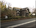
1
Nant Iago flows past Pentre Lodge near Abergavenny
Vigorous in February during the very rainy winter of 2013-2014, the stream Nant Iago flows towards the A40 Brecon Road. Nant Iago flows into the River Usk about a kilometre behind the camera.
Image: © Jaggery
Taken: 7 Feb 2014
0.00 miles
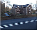
2
Pentre Lodge, Llanwenarth
Viewed across the A40. The lodge probably dates from the early 19th century.
It was first recorded on the Tithe Map of 1844.
A tributary of the River Usk, Nant Iago is on the left.
Image: © Jaggery
Taken: 29 Dec 2019
0.01 miles
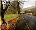
3
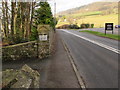
No overtaking on the A40 Brecon Road, Llanwenarth
Double white lines indicate no overtaking.
Ahead for Abergavenny. Behind the camera for Crickhowell and Brecon.
Image: © Jaggery
Taken: 29 Dec 2019
0.02 miles
4
Gap in the fence alongside the A40 Brecon Road, Llanwenarth
Viewed on December 29th 2019. A notice https://www.geograph.org.uk/photo/6354810 near the camera suggests that the break in the fence was caused by a collision on July 24th 2019.
Image: © Jaggery
Taken: 29 Dec 2019
0.02 miles
5
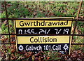
Gwrthdrawiad/Collision police notice facing the A40 Brecon Road, Llanwenarth
Near a gap in a roadside fence https://www.geograph.org.uk/photo/6354808 the Welsh/English notice refers to a collision at 1:55am on July 24th 2019.
Image: © Jaggery
Taken: 29 Dec 2019
0.02 miles
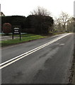
6
Exit road from Pentre Court, Llanwenarth
From the left, the exit road from Pentre Court https://www.geograph.org.uk/photo/2501787 joins the A40 Brecon Road.
Image: © Jaggery
Taken: 29 Dec 2019
0.02 miles
7
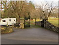
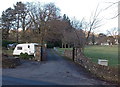
Entrance gates to the Pentre, Llanwenarth
Across a private road on the north side of the A40 Brecon Road near Abergavenny.
Image: © Jaggery
Taken: 29 Dec 2019
0.02 miles
8
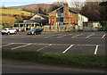
Lamb & Flag, Llanwenarth
S.A. Brain & Co Ltd pub with accommodation set back 40 metres from the A40 Brecon Road near Abergavenny.
https://www.geograph.org.uk/photo/6353909 to the Lamb & Flag name sign out of shot nearby.
Image: © Jaggery
Taken: 29 Dec 2019
0.03 miles
9
Entrance drive to The Pentre west of Abergavenny
On the north side of the A40 Brecon Road.
Image: © Jaggery
Taken: 7 Feb 2014
0.03 miles
10
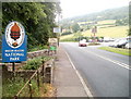
Eastern edge of Brecon Beacons National Park near Abergavenny
Heading NW away from Abergavenny, the A40 (Brecon Road) enters the Brecon Beacons National Park.
On the left is an entrance to Pentre Court. http://www.geograph.org.uk/photo/2501787
On the right is the Lamb & Flag. http://www.geograph.org.uk/photo/2501736
Image: © Jaggery
Taken: 19 Jun 2011
0.04 miles