IMAGES TAKEN NEAR TO
Pentre Road, ABERGAVENNY, NP7 7BH
Introduction
This page details the photographs taken nearby to Pentre Road, NP7 7BH by members of the Geograph project.
The Geograph project started in 2005 with the aim of publishing, organising and preserving representative images for every square kilometre of Great Britain, Ireland and the Isle of Man.

There are currently over 7.5m images from over14,400 individuals and you can help contribute to the project by visiting https://www.geograph.org.uk
Image Map
Images are licensed for reuse under creativecommons.org/licenses/by-sa/2.0
Notes
- Clicking on the map will re-center to the selected point.
- The higher the marker number, the further away the image location is from the centre of the postcode.
Image Listing (41 Images Found)
Images are licensed for reuse under creativecommons.org/licenses/by-sa/2.0
Image
Details
Distance
1
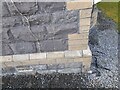
Ordnance Survey Cut Mark
This OS cut mark can be found on No9 Windsor Road. It marks a point 70.031m above mean sea level.
Image: © Adrian Dust
Taken: 23 Sep 2022
0.03 miles
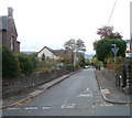
2
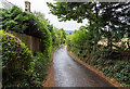
Pentre Road
A very narrow lane on the outskirts of Abergavenny.
Image: © David P Howard
Taken: 2 Aug 2016
0.04 miles
3
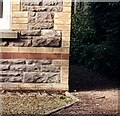
Ordnance Survey Cut Mark
This OS cut mark can be found on No6 Albany Road. It marks a point 75.690m above mean sea level.
Image: © Adrian Dust
Taken: 23 Sep 2022
0.05 miles
4
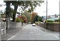
Chapel Road, Abergavenny
Chapel Road heads south away from Pentre Road.
Image: © Jaggery
Taken: 22 Oct 2010
0.09 miles
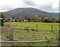
5

Fields north of Pentre Road
Fields on the northern edge of Abergavenny.
Image: © David P Howard
Taken: 2 Aug 2016
0.09 miles
6
Western Road, Abergavenny
Western Road heads away from Chapel Road towards Cresta Road, about 450 metres away.
Image: © Jaggery
Taken: 22 Oct 2010
0.11 miles
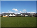
7
Abergavenny : field with a mountain backdrop
Looking from Pentre Lane across a field towards Pentre Road houses. In the background is the Blorenge. Image Its peak is 561 metres (1841 feet) above sea level.
Image: © Jaggery
Taken: 22 Oct 2010
0.11 miles
8
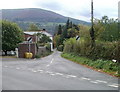
Pentre Road, Abergavenny
Pentre Road heads SW away from the northern end of Chapel Road, which has followed
a NNW course for about 900 metres from Brecon Road.
Image: © Jaggery
Taken: 22 Oct 2010
0.11 miles
9
Part of Belgrave Park, Abergavenny
With a view towards the Sugar Loaf / Mynydd Pen y Fal over the roofs of Western Road and between Mynydd Llanwenarth and the Rholben.
Image: © Jeremy Bolwell
Taken: 30 Mar 2013
0.12 miles
10
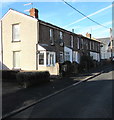
Row of houses at the northern end of North Street, Abergavenny
The house at the far end of the row is opposite the point where
the northerly course of North Street bends to the east towards Chapel Street.
Image: © Jaggery
Taken: 29 Dec 2019
0.14 miles