IMAGES TAKEN NEAR TO
Coed Y Brenin, ABERGAVENNY, NP7 6PY
Introduction
This page details the photographs taken nearby to Coed Y Brenin, NP7 6PY by members of the Geograph project.
The Geograph project started in 2005 with the aim of publishing, organising and preserving representative images for every square kilometre of Great Britain, Ireland and the Isle of Man.

There are currently over 7.5m images from over14,400 individuals and you can help contribute to the project by visiting https://www.geograph.org.uk
Image Map
Images are licensed for reuse under creativecommons.org/licenses/by-sa/2.0
Notes
- Clicking on the map will re-center to the selected point.
- The higher the marker number, the further away the image location is from the centre of the postcode.
Image Listing (32 Images Found)
Images are licensed for reuse under creativecommons.org/licenses/by-sa/2.0
Image
Details
Distance

2
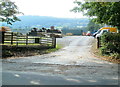
Entrance to Woodlands Services & Supplies Ltd north of Llantilio Pertholey
Viewed across Hereford Road. Products available here include agricultural & domestic fencing materials and bottled gas.
Image: © Jaggery
Taken: 1 Sep 2011
0.10 miles
3
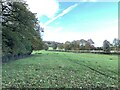
Path adjacent to Ty-Gwyn Road
Heading north west.
Image: © Andrew Abbott
Taken: 30 Oct 2021
0.13 miles
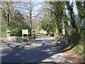
4
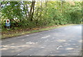
Southern boundary of Brecon Beacons National Park near Llantilio Pertholey
A sign alongside Hereford Road, to the north of Llantilio Pertholey, marks the southern edge of the National Park. The southern boundary of the park is river-like in its meandering course. The SE edge is 16 kilometres (10 miles) south of here, at New Inn, Pontypool. http://www.geograph.org.uk/photo/2486975
Image: © Jaggery
Taken: 1 Sep 2011
0.13 miles
5
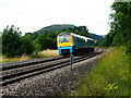
The Marches Line
13:10 Arriva Trains Wales service from Milford Haven to Shrewsbury. Seen here just north of Abergavenny. In the distance can be seen the small hill of Bryn Arw 381m
Image: © Stuart Wilding
Taken: 19 Jul 2008
0.14 miles
6
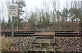
Level crossing, Llantilio Pertholey
Public footpath across Welsh Marches Line; the metal barrier behind the trees borders the A465.
Image: © M J Roscoe
Taken: 23 Jan 2020
0.16 miles
7
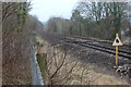
Railway line south towards Abergavenny
Welsh Marches Line, with pedestrian crossing Image The leaf sign indicates the start of a high leaf fall area.
Image: © M J Roscoe
Taken: 23 Jan 2020
0.17 miles
8
Entrance to Ty-Gwyn Hall
Ty Gwyn Hall is an independent hospital providing therapeutic support, treatment and rehabilitation for men and women with complex mental illnesses.
Image: © Colin Madge
Taken: 19 Mar 2011
0.17 miles
9
Houses, Llantilio Pertholey
Northern edge of settlement with tower of St Teilo's Church on skyline.
Image: © M J Roscoe
Taken: 23 Jan 2020
0.17 miles
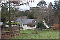
10
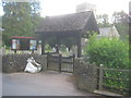
Lych Gate at St Telio's church.
At Llantilio Pertholey showing part of the church and churchyard
Image: © Peter Robinson
Taken: 29 May 2015
0.18 miles