IMAGES TAKEN NEAR TO
Llantilio Pertholey, ABERGAVENNY, NP7 6NY
Introduction
This page details the photographs taken nearby to NP7 6NY by members of the Geograph project.
The Geograph project started in 2005 with the aim of publishing, organising and preserving representative images for every square kilometre of Great Britain, Ireland and the Isle of Man.

There are currently over 7.5m images from over14,400 individuals and you can help contribute to the project by visiting https://www.geograph.org.uk
Image Map
Images are licensed for reuse under creativecommons.org/licenses/by-sa/2.0
Notes
- Clicking on the map will re-center to the selected point.
- The higher the marker number, the further away the image location is from the centre of the postcode.
Image Listing (62 Images Found)
Images are licensed for reuse under creativecommons.org/licenses/by-sa/2.0
Image
Details
Distance
1
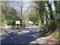
Entrance to Ty-Gwyn Hall
Ty Gwyn Hall is an independent hospital providing therapeutic support, treatment and rehabilitation for men and women with complex mental illnesses.
Image: © Colin Madge
Taken: 19 Mar 2011
0.02 miles
2
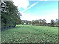
Path adjacent to Ty-Gwyn Road
Heading north west.
Image: © Andrew Abbott
Taken: 30 Oct 2021
0.05 miles
3
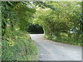
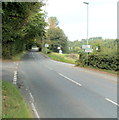
Road from Llantilio Pertholey to Pantygelli and Bettws
Viewed from near the Hereford Road junction. http://www.geograph.org.uk/photo/2581134
Image: © Jaggery
Taken: 1 Sep 2011
0.07 miles
4
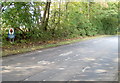
Southern boundary of Brecon Beacons National Park near Llantilio Pertholey
A sign alongside Hereford Road, to the north of Llantilio Pertholey, marks the southern edge of the National Park. The southern boundary of the park is river-like in its meandering course. The SE edge is 16 kilometres (10 miles) south of here, at New Inn, Pontypool. http://www.geograph.org.uk/photo/2486975
Image: © Jaggery
Taken: 1 Sep 2011
0.08 miles
5
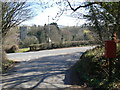
Crossroads, Llantilio Pertholey
The main road, straight ahead, is Hereford Road. On the left is the road to Pantygelli and Bettws; on the right, the road to the hamlet of Llantilio Pertholey.
Image: © Jaggery
Taken: 1 Sep 2011
0.10 miles
7
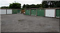
Lockup garages in Mardy
Located between Greystones Crescent and Poplars Close.
Image: © Jaggery
Taken: 7 Aug 2017
0.13 miles
8
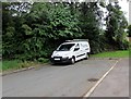
O.D.Electrical van in Mardy
Parked at the northwest end of Greystones Crescent. O.D.Electrical is based in nearby Abergavenny.
Image: © Jaggery
Taken: 7 Aug 2017
0.14 miles
9
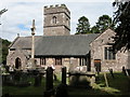
St. Teilo church, Llantilio Pertholey
See: http://www.villagealivetrust.org.uk/churches.htm
Image: © Philip Halling
Taken: 6 Aug 2006
0.15 miles
10
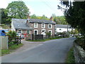
Converted pub and cottages, Llantilio Pertholey
The grey stone house was formerly the village pub, the Old Mitre. The white houses are numbers 1 and 2 Mitre Cottages.
Image: © Jaggery
Taken: 1 Sep 2011
0.15 miles