IMAGES TAKEN NEAR TO
Springwells, ABERGAVENNY, NP7 6NW
Introduction
This page details the photographs taken nearby to Springwells, NP7 6NW by members of the Geograph project.
The Geograph project started in 2005 with the aim of publishing, organising and preserving representative images for every square kilometre of Great Britain, Ireland and the Isle of Man.

There are currently over 7.5m images from over14,400 individuals and you can help contribute to the project by visiting https://www.geograph.org.uk
Image Map
Images are licensed for reuse under creativecommons.org/licenses/by-sa/2.0
Notes
- Clicking on the map will re-center to the selected point.
- The higher the marker number, the further away the image location is from the centre of the postcode.
Image Listing (43 Images Found)
Images are licensed for reuse under creativecommons.org/licenses/by-sa/2.0
Image
Details
Distance
1
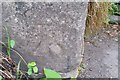
Ordnance Survey Cut Mark
This OS cut mark can be found on the NW side of the Road. It marks a point 78.684m above mean sea level.
Image: © Adrian Dust
Taken: 3 Jul 2020
0.03 miles
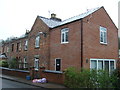
5
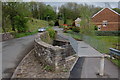
Bridges over the River Gavenny
A new footbridge has been added to this old road bridge over the River Gavenny presumably to give safer pedestrian access to the new houses on the right.
Image: © Roger Davies
Taken: 27 Apr 2008
0.08 miles
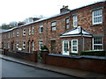
6
Ross Road bridge over the River Gavenny
View looks northwards from the Ross Road on the outskirts of Abergavenny.
Image: © Roger Davies
Taken: 4 May 2008
0.08 miles
7
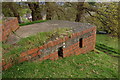
WW2 pillbox overlooking the River Gavenny
View looks south-westwards. This is a variant pillbox in a commanding position near the road bridge carrying the B4521 over the River Gavenny near Abergavenny. The embrasures indicate it was designed to repel an attacking force from the north. Presumably this pillbox formed part of the 'Usk Stopline' defences constructed in 1940-41 (the river Usk flows through Abergavenny some 1.5 miles to the south).
Image: © Roger Davies
Taken: 27 Apr 2008
0.09 miles
8
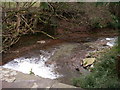
Afon Gafenni from Ross Road
The B4521 Ross Road out of Abergavenny crosses the Afon Gafenni / Gavenny River by means of a stone arch bridge from the parapet of which can be seen the gushing waters of the river as they run over their rocky bed cut into the local Old Red Sandstone ('St Maughan's Formation' mudstones and sandstones). Abergavenny gets its (English!) name from its site at the point where this river enters the Afon Wysg / River Usk. The Welsh name is 'Y Fenni'.
Image: © Alan Bowring
Taken: 11 Mar 2007
0.09 miles
9
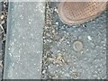
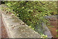
OS rivet in pavement
Beside old toll house on old Ross Road at 81.613m - https://interactivemaps.uk/os-benchmark-archive/#16.99/51.828278/-3.005984
Image: © Martin Laverty
Taken: 3 Feb 2023
0.09 miles
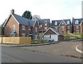
10
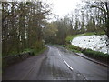
Ross Road (B4521)
Leaving Abergavenny - looking north east.
Image: © JThomas
Taken: 4 Apr 2019
0.10 miles