IMAGES TAKEN NEAR TO
St. Teilos Road, ABERGAVENNY, NP7 6HB
Introduction
This page details the photographs taken nearby to St. Teilos Road, NP7 6HB by members of the Geograph project.
The Geograph project started in 2005 with the aim of publishing, organising and preserving representative images for every square kilometre of Great Britain, Ireland and the Isle of Man.

There are currently over 7.5m images from over14,400 individuals and you can help contribute to the project by visiting https://www.geograph.org.uk
Image Map
Images are licensed for reuse under creativecommons.org/licenses/by-sa/2.0
Notes
- Clicking on the map will re-center to the selected point.
- The higher the marker number, the further away the image location is from the centre of the postcode.
Image Listing (47 Images Found)
Images are licensed for reuse under creativecommons.org/licenses/by-sa/2.0
Image
Details
Distance
1
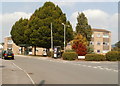
Bus shelter and phone box, St David's Road, Mardy
Dwarfed by trees, the phone box and bus shelter are at the southern edge of St David's Road, viewed from the northern edge of St Teilo's Road.
Image: © Jaggery
Taken: 1 Sep 2011
0.03 miles
2
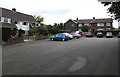
Northern end of St Francis Close, Mardy
St Francis Close is set back from the west side of Hereford Road.
Image: © Jaggery
Taken: 7 Aug 2017
0.07 miles
3
St Francis Close, Mardy
Set back from the west side of Hereford Road.
Image: © Jaggery
Taken: 7 Aug 2017
0.08 miles
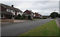
4
Croesonen Cottages, Mardy
Semi-detached houses, Hereford Road, Mardy.
Image: © Jaggery
Taken: 1 Sep 2011
0.08 miles
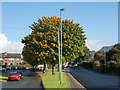
5
Roadside trees, Mardy
Viewed from St Francis Close. Hereford Road is behind the trees.
Image: © Jaggery
Taken: 7 Aug 2017
0.08 miles
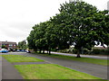
6
Grassed strip with trees
The narrow strip of grass lies between two roads; the residential St. Francis Close to the left and Hereford Road to the right. Presumably Hereford Road was once the main road north out of Abergavenny; it has now been superseded by a new road to the east avoiding the town.
Image: © Trevor Littlewood
Taken: 15 Oct 2016
0.09 miles
7
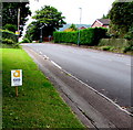
Abergavenny Food Festival 2017 advert, Hereford Road, Mardy
The advert facing northbound traffic shows that Abergavenny Food
Festival 2017 will be held on the weekend of September 16th & 17th.
Image: © Jaggery
Taken: 7 Aug 2017
0.09 miles
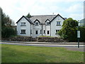
8
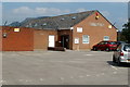
Llantilio Pertholey Community Hall, Mardy
Located on the NE side of St David's Road, Mardy. The hall is owned by Llantilio Pertholey Community Council, and is used by locals for a wide variety of activities. These include Bingo Club, Buzzy Bees Mothers & Toddlers, Cardiac Rehabilitation Group, Llantilio Pertholey Women's Institute, Llantilio Pertholey Village Produce Association, Mardy Indoor Short Mat Bowls, Mardy Bridge Club, Aerobics, Martial Arts, Abergavenny Art Group and Women of The World Church Group.
Image: © Jaggery
Taken: 1 Sep 2011
0.09 miles
9
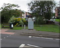
Public area on the west side of Hereford Road, Mardy
Items in view include a bench, litter bin and Llantilio Pertholey Community Council noticeboard.
St David's Road is behind the trees, bushes and low wall.
Image: © Jaggery
Taken: 7 Aug 2017
0.10 miles
10
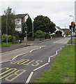
Hereford Road pelican crossing, Mardy
Chambers Dictionary states that pelican in this context is adapted from "pedestrian light controlled crossing".
Image: © Jaggery
Taken: 7 Aug 2017
0.10 miles