IMAGES TAKEN NEAR TO
Clos Bury Capel, ABERGAVENNY, NP7 6AU
Introduction
This page details the photographs taken nearby to Clos Bury Capel, NP7 6AU by members of the Geograph project.
The Geograph project started in 2005 with the aim of publishing, organising and preserving representative images for every square kilometre of Great Britain, Ireland and the Isle of Man.

There are currently over 7.5m images from over14,400 individuals and you can help contribute to the project by visiting https://www.geograph.org.uk
Image Map (Loading...)


Getting Data...Please wait
Leaflet Map data © OpenStreetMap
Images are licensed for reuse under creativecommons.org/licenses/by-sa/2.0
Notes
- Clicking on the map will re-center to the selected point.
- The higher the marker number, the further away the image location is from the centre of the postcode.
Image Listing (31 Images Found)
Images are licensed for reuse under creativecommons.org/licenses/by-sa/2.0
Image
Details
Distance
1
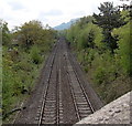
Marches Line railway and a distant view of The Skirrid, Abergavenny
Viewed from the B4233 on this http://www.geograph.org.uk/photo/3466956 bridge.
In the distance is The Skirrid Image also known as Skirrid Fawr (Ysgyryd Fawr in Welsh).
The jagged side was caused by Ice Age landslips.
Image: © Jaggery
Taken: 17 May 2013
0.02 miles
2
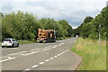
Timber on A465 heading to sawmill
Pontrilas Sawmills timber lorry heading north.
Image: © M J Roscoe
Taken: 12 Aug 2021
0.03 miles
3
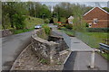
Bridges over the River Gavenny
A new footbridge has been added to this old road bridge over the River Gavenny presumably to give safer pedestrian access to the new houses on the right.
Image: © Roger Davies
Taken: 27 Apr 2008
0.10 miles
4
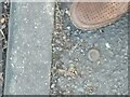
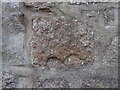
OS rivet in pavement
Beside old toll house on old Ross Road at 81.613m - https://interactivemaps.uk/os-benchmark-archive/#16.99/51.828278/-3.005984
Image: © Martin Laverty
Taken: 3 Feb 2023
0.11 miles
5

Teasel plant on Grosvenor Road
One of the examples of teasel seed heads growing by the roadside here.
Image: © David P Howard
Taken: 2 Aug 2016
0.11 miles
6
Llanvihangel Tramroad remnant in wall
Characteristic double crescent (cf embankment at Wern-Gifford https://www.geograph.org.uk/photo/635831 ) carved into rail attachment block, now incorporated into wall by junction of Clifton Road, Grosvenor Road, and Ross Road, roughly where it was when the tramroad ran for a few decades from around 1812. There are more blocks, with holes from the attachment spike pegs, in the low wall opposite between Grosvenor and Ross Roads.
Image: © Martin Laverty
Taken: 15 Aug 2023
0.12 miles
7

Lane beneath the railway and road bridges near Abergavenny
The older and more elegant railway bridge arch frames the more modern but far more utilitarian concrete road bridge. Some walkers offer scale.
Image: © Jeremy Bolwell
Taken: 6 Oct 2011
0.13 miles
8
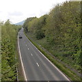
A465 NNE of the B4233, Abergavenny
The A465 here runs parallel with the Welsh Marches railway, http://www.geograph.org.uk/photo/3466994
just out of shot beyond the vegetation on the left.
Image: © Jaggery
Taken: 17 May 2013
0.14 miles
9
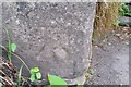
Ordnance Survey Cut Mark
This OS cut mark can be found on the NW side of the Road. It marks a point 78.684m above mean sea level.
Image: © Adrian Dust
Taken: 3 Jul 2020
0.14 miles
10
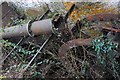
Waterwheels at Mill House
Very rare Tandem Waterwheels at Mill House. One of the five corn mills that used to be driven by the Gavenny river near Abergavenny. Both wheels operate in the same flow of water, in the same pit.
Image: © RAY JONES
Taken: 9 Jan 2007
0.16 miles