1
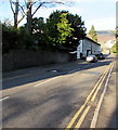
Pen-y-pound houses, Abergavenny
Houses on the west side of the street, viewed from the edge of Whitefield Presbyterian Church. http://www.geograph.org.uk/photo/2735186
Image: © Jaggery
Taken: 7 Dec 2011
0.02 miles
2
Grade II listed The Drama Centre, Abergavenny
Located on the east side of Pen-y-pound, between Park Crescent and Park Road.
The Drama Centre is used by the Melville Theatre. There are regular programmes of plays, films and workshops, with a particular focus on and for young people.
The Drama Centre was formerly King Henry VIII Grammar School, built in 1898, Grade II listed in October 1995.
Image: © Jaggery
Taken: 7 Dec 2011
0.02 miles
3
Southern entrance to Our Lady and Saint Michael's RC primary school, Abergavenny
The Roman Catholic primary school is located on the west side of Pen-y-pound, near Grade II* listed Priory Church of Our Lady and Saint Michael. http://www.geograph.org.uk/photo/2745104
Image: © Jaggery
Taken: 7 Dec 2011
0.02 miles
4
No parking in Pen-y-Pound, Abergavenny
Double yellow lines on both sides of the road named Pen-y-Pound indicate no parking at any time.
A painted white triangle is on a speed bump.
Image: © Jaggery
Taken: 29 Dec 2019
0.03 miles
5
Drama Centre - former King Henry VIII school
The original King Henry VIII school was founded in 1543 and moved to this new facility after its construction in 1898. Designed by E A Johnson it was expanded to the north in 1904 and again in 1926 with three new classrooms, a gymnasium and a library. It ceased to be a school on the opening of the next iteration of the school off the Old Hereford Road in 1970 - see
Image and is now a Drama Centre and Careers Advice Centre. It was listed as Grade II by Cadw in 1995.
Image: © Colin Cheesman
Taken: 25 Jun 2020
0.03 miles
6
Abergavenny Labour Hall
Abergavenny Labour Hall and Institute is located at 110 Park Crescent.
Image: © Jaggery
Taken: 7 Dec 2011
0.04 miles
7
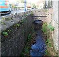
Afon Cibi, Abergavenny
The Afon Cibi here flows along the eastern edge of Pen-y-pound. The stream is a tributary of the River Gavenny into which it flows about 100 metres from the confluence of the Gavenny and the Usk, about a kilometre SE of here.
Image: © Jaggery
Taken: 7 Dec 2011
0.04 miles
8
Mulberry House, Abergavenny
Residential conference centre located on Pen-y-pound, facing The Tollhouse. http://www.geograph.org.uk/photo/2745162
Image: © Jaggery
Taken: 7 Dec 2011
0.04 miles
9
Ty'r Morwydd (St Michael's Convent)
Category II listed. Listing reference 2469.
The house became a Convent of Breton nuns in 1906 and they ran a girls school for many years.
Image: © Andrew Abbott
Taken: 30 Oct 2021
0.04 miles
10
Grade II Listed Alandale, Pen-y-Pound, Abergavenny
Cadw records that Alandale is an early 19th century simple classical house which is shown on Wood's map of 1834. It was formerly the manse (minister's house) for the adjacent Whitefield Presbyterian Church https://www.geograph.org.uk/photo/2735186.
Alandale was Grade II Listed in 2002.
Image: © Jaggery
Taken: 29 Dec 2019
0.06 miles


