IMAGES TAKEN NEAR TO
Monk Street, ABERGAVENNY, NP7 5ND
Introduction
This page details the photographs taken nearby to Monk Street, NP7 5ND by members of the Geograph project.
The Geograph project started in 2005 with the aim of publishing, organising and preserving representative images for every square kilometre of Great Britain, Ireland and the Isle of Man.

There are currently over 7.5m images from over14,400 individuals and you can help contribute to the project by visiting https://www.geograph.org.uk
Image Map
Images are licensed for reuse under creativecommons.org/licenses/by-sa/2.0
Notes
- Clicking on the map will re-center to the selected point.
- The higher the marker number, the further away the image location is from the centre of the postcode.
Image Listing (948 Images Found)
Images are licensed for reuse under creativecommons.org/licenses/by-sa/2.0
Image
Details
Distance
1
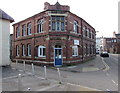
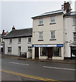
Fonseca office in Abergavenny
The office of Fonseca and Partners (solicitors) is in St Mary's Chambers, Monk Street.
Image: © Jaggery
Taken: 18 Oct 2018
0.00 miles
2
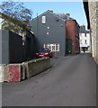
Beili Priory, Abergavenny
The road named Beili Priory extends from the edge of Abergavenny Bus Station Car Park to Monk Street (ahead). The edge of the Tithe Barn is on the right.
Image: © Jaggery
Taken: 18 Oct 2018
0.00 miles
3
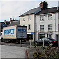
React lorry, Monk Street, Abergavenny
React Transport Services Ltd was founded in 1992. In 2018 the business
has UK depots in Livingston, Manchester and Reading and a depot in France.
Image: © Jaggery
Taken: 18 Oct 2018
0.00 miles
4
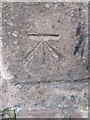
Ordnance Survey Cut Mark
This OS cut mark can be found on a gatepost at St Mary's Church. It marks a point 56.388m above mean sea level.
Image: © Adrian Dust
Taken: 4 Jun 2014
0.01 miles
5
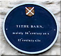
Tithe Barn blue plaque, Abergavenny
On the wall here. https://www.geograph.org.uk/photo/2571740
Image: © Jaggery
Taken: 31 Dec 2017
0.01 miles
6
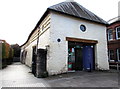
Abergavenny Tourist Information Centre
Viewed in October 2018. Formerly located about 150 metres away in this https://www.geograph.org.uk/photo/5945664 building near the bus station,
Abergavenny Tourist Information Centre is now in the Grade II (star) listed Tithe Barn. The irregular appearance of the left side of the building is not a photographic aberration. https://www.geograph.org.uk/photo/2571740 to an earlier view of the Tithe Barn and a few details of its history.
Image: © Jaggery
Taken: 18 Oct 2018
0.01 miles
7
Tithe Barn
Barn near St Mary's Church, dating from the 12th Century according to its website or from the c.16th Century according to its listing particulars. Following the dissolution of the monasteries in the 16th Century, its website says that it became a coach house, then over time a theatre, a shop, a carpet warehouse, an auction house and a disco. In 2003-4 it underwent a major refurbishment and restoration and is now a community education and art space. Grade II* listed - see https://cadwpublic-api.azurewebsites.net/reports/listedbuilding/FullReport?lang=&id=2375.
Image: © Ian Capper
Taken: 9 Sep 2021
0.01 miles
8
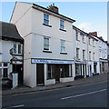
Cobra in Abergavenny
Cobra UK & Ireland Insurance office at 12 Monk Street.
Image: © Jaggery
Taken: 19 Dec 2014
0.01 miles
9
UK & Ireland Insurance Services office in Abergavenny
At 12 Monk Street.
Image: © Jaggery
Taken: 31 Dec 2017
0.01 miles
10
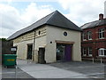
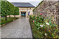
Tithe Barn, Abergavenny
The 12th century tithe barn that is part of St Marys Priory in Abergavenny. The barn was restored in 2002 but to my mind the glass doors detract from telling the story of what the buildings purpose was. It now houses a display about local history and the inevitable cafe rather splendidly entitled a food hall!
Image: © Colin Cheesman
Taken: 2 May 2009
0.01 miles