1
Snowbridge.
Snow gives a magical touch to this footbridge over the River Gavenny.
Image: © G Bradshaw
Taken: 8 Feb 2007
0.05 miles
2
Sycamore Avenue, Abergavenny
Viewed from the Old Monmouth Road end. Formerly a road through Pen-y-Fal Hospital,
now a road through an area of housing named Parc Pen-y-Fal.
Image: © Jaggery
Taken: 17 May 2013
0.05 miles
3
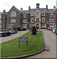
The former hospital - now flats.
Image: © Ruth Sharville
Taken: 28 Jul 2009
0.05 miles
4
Hospital into housing
This former hospital on the eastern edge of Abergavenny has been converted into dwellings in parkland surrounds.
Image: © Alan Bowring
Taken: 1 Apr 2007
0.05 miles
5
NW side of the former Pen-y-fal Hospital, Abergavenny
Viewed from Sycamore Avenue. The building has been converted to housing.
Built in 1849-1852 as a lunatic asylum (as it was then termed) in the Tudor Gothic style to house
250 patients, to serve the counties of Monmouth, Brecon, Hereford and Radnor.
Image: © Jaggery
Taken: 17 May 2013
0.05 miles
6
Gavenny Way, Abergavenny
Viewed from the B4233 Old Monmouth Road. Ahead is the left turn into Ostringen Close.
Östringen in Germany is one of Abergavenny's twin towns.
Image: © Jaggery
Taken: 17 May 2013
0.05 miles
7
Sarno Square, Abergavenny
Viewed from Sycamore Avenue looking towards the clock tower of the former Pen-y-Fal Hospital,
built in 1849-1852 as a lunatic asylum (as it was then termed) in the Tudor Gothic style to house 250 patients, to serve the counties of Monmouth, Brecon, Hereford and Radnor. Now in use as housing.
Image: © Jaggery
Taken: 17 May 2013
0.06 miles
8
Abergavenny, St. Mary's Priory Church: Sir Andrew Powell (d.1631) and wife Margaret (d.1641) memorial
Image: © Michael Garlick
Taken: 12 Jun 2021
0.06 miles
9
Abergavenny, St. Mary's Priory Church: Sir Lawrence de Hastings (d.1348) memorial
Image: © Michael Garlick
Taken: 12 Jun 2021
0.06 miles
10
Inner bay, Sarno Square, Abergavenny
In the central bay at the rear of Sarno Square, formerly Pen-y-fal Hospital now converted to flats.
Image: © M J Roscoe
Taken: 25 May 2016
0.06 miles


