IMAGES TAKEN NEAR TO
Bay Tree Lane, ABERGAVENNY, NP7 5JW
Introduction
This page details the photographs taken nearby to Bay Tree Lane, NP7 5JW by members of the Geograph project.
The Geograph project started in 2005 with the aim of publishing, organising and preserving representative images for every square kilometre of Great Britain, Ireland and the Isle of Man.

There are currently over 7.5m images from over14,400 individuals and you can help contribute to the project by visiting https://www.geograph.org.uk
Image Map
Images are licensed for reuse under creativecommons.org/licenses/by-sa/2.0
Notes
- Clicking on the map will re-center to the selected point.
- The higher the marker number, the further away the image location is from the centre of the postcode.
Image Listing (75 Images Found)
Images are licensed for reuse under creativecommons.org/licenses/by-sa/2.0
Image
Details
Distance
1
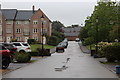
Bay Tree Lane, Abergavenny
Lane viewed from end of private road almost under clock tower of Sarno Square.
Image: © M J Roscoe
Taken: 19 Aug 2015
0.02 miles
2
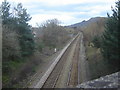
Railway at Abergavenny, going towards Hereford
Taken from the B4233 bridge. The A465 is just to the right off the shot.
Image: © Ruth Sharville
Taken: 13 Mar 2007
0.06 miles
3
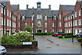
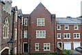
Rear of Sarno Square, Abergavenny
Sarno Square, formerly part of Pen-y-Fal Hospital, now converted to flats, viewed from the end of Bay Tree Lane, Image
Image: © M J Roscoe
Taken: 19 Aug 2015
0.06 miles
4
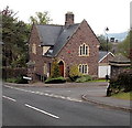
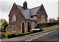
Former hospital lodge on the west side of Chestnut Drive, Abergavenny
Viewed across Old Monmouth Road. Now a private residence, formerly a lodge at an entrance
to Pen-y-fal Hospital. There is a similar lodge 10 metres away, facing this one on the opposite side
of Chestnut Drive, just out of shot on the right. http://www.geograph.org.uk/photo/3470276
Image: © Jaggery
Taken: 17 May 2013
0.07 miles
5
Inner bay, Sarno Square, Abergavenny
In the central bay at the rear of Sarno Square, formerly Pen-y-fal Hospital now converted to flats.
Image: © M J Roscoe
Taken: 25 May 2016
0.07 miles
6
Former hospital lodge on the east side of Chestnut Drive, Abergavenny
Viewed across Old Monmouth Road. Now a private residence, formerly a lodge at an entrance
to Pen-y-fal Hospital. There is a similar lodge 10 metres away, http://www.geograph.org.uk/photo/3470284
facing this one on the opposite side of Chestnut Drive.
Image: © Jaggery
Taken: 17 May 2013
0.07 miles
7
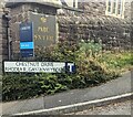
Bilingual Chestnut Drive name sign, Abergavenny
The sign facing the B4233 shows that CHESTNUT DRIVE is RHODFA'R GASTANWYDDEN in Welsh.
Image: © Jaggery
Taken: 11 Aug 2024
0.07 miles
8
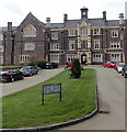
Sarno Square, Abergavenny
Viewed from Sycamore Avenue looking towards the clock tower of the former Pen-y-Fal Hospital,
built in 1849-1852 as a lunatic asylum (as it was then termed) in the Tudor Gothic style to house 250 patients, to serve the counties of Monmouth, Brecon, Hereford and Radnor. Now in use as housing.
Image: © Jaggery
Taken: 17 May 2013
0.08 miles
9
From stone to brick, Abergavenny
Change in material on the wall on the north side of the bridge carrying
the B4233 over the Welsh Marches railway line and the A465. The red-edged
bridge identifier shows "Asylum Road" https://www.geograph.org.uk/photo/7846967
Image: © Jaggery
Taken: 11 Aug 2024
0.08 miles
10
Asylum Road railway bridge identifier, Abergavenny
Located here. https://www.geograph.org.uk/photo/7846885
Image: © Jaggery
Taken: 11 Aug 2024
0.08 miles