IMAGES TAKEN NEAR TO
Station Road, ABERGAVENNY, NP7 5HT
Introduction
This page details the photographs taken nearby to Station Road, NP7 5HT by members of the Geograph project.
The Geograph project started in 2005 with the aim of publishing, organising and preserving representative images for every square kilometre of Great Britain, Ireland and the Isle of Man.

There are currently over 7.5m images from over14,400 individuals and you can help contribute to the project by visiting https://www.geograph.org.uk
Image Map
Images are licensed for reuse under creativecommons.org/licenses/by-sa/2.0
Notes
- Clicking on the map will re-center to the selected point.
- The higher the marker number, the further away the image location is from the centre of the postcode.
Image Listing (192 Images Found)
Images are licensed for reuse under creativecommons.org/licenses/by-sa/2.0
Image
Details
Distance
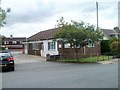
1
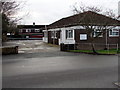
Driving Test Centre, Abergavenny
Driver & Vehicle Standards Agency site on the south side of Station Road.
Image: © Jaggery
Taken: 31 Dec 2017
0.00 miles
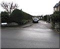
2
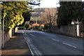
Station Road towards Abergavenny railway station
From the corner of the A40 Monmouth Road. The station http://www.geograph.org.uk/photo/2652374 is 250 metres ahead.
Image: © Jaggery
Taken: 19 Dec 2014
0.01 miles
3
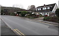
Station Road houses, Abergavenny
On the south side of Station Road on the approach to Abergavenny railway station.
Station Road dates from the 1850s. These houses were built many decades later.
Image: © Jaggery
Taken: 31 Dec 2017
0.02 miles
4
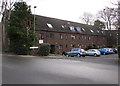
Marsh Court, Abergavenny
Flats on the south side of Station Road near Abergavenny railway station.
Image: © Jaggery
Taken: 31 Dec 2017
0.02 miles
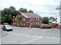
5
Driving Test Centre, Abergavenny
Located on Station Road, this is one of more than 400 Driving Test Centres in the UK. Driving tests are conducted by examiners of the Driving Standards Agency, an executive agency of the Department for Transport.
Image: © Jaggery
Taken: 19 Jun 2011
0.02 miles
6
Willow Close flats, Abergavenny
Viewed across Station Road.
Image: © Jaggery
Taken: 19 Jun 2011
0.02 miles
7
Limetree Mews and Limetree Court, Abergavenny
On the south side of Station Road near Abergavenny railway station.
Image: © Jaggery
Taken: 31 Dec 2017
0.03 miles
8
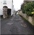
Patched surface on a side road in Abergavenny
Viewed from Station Road. The unnamed side road leads to Belmont Close.
Image: © Jaggery
Taken: 31 Dec 2017
0.04 miles
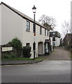
9
St Ronans, Abergavenny
Cul-de-sac and private road on the south side of Station Road.
Image: © Jaggery
Taken: 31 Dec 2017
0.04 miles
10
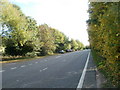
Southbound A465, Abergavenny
The A465 here runs parallel with the railway lines south of Abergavenny Station, which is about 40 metres away, on the other side of the hedge on the right.
Image: © Jaggery
Taken: 20 Oct 2010
0.04 miles