IMAGES TAKEN NEAR TO
Fosterville Crescent, ABERGAVENNY, NP7 5HG
Introduction
This page details the photographs taken nearby to Fosterville Crescent, NP7 5HG by members of the Geograph project.
The Geograph project started in 2005 with the aim of publishing, organising and preserving representative images for every square kilometre of Great Britain, Ireland and the Isle of Man.

There are currently over 7.5m images from over14,400 individuals and you can help contribute to the project by visiting https://www.geograph.org.uk
Image Map
Images are licensed for reuse under creativecommons.org/licenses/by-sa/2.0
Notes
- Clicking on the map will re-center to the selected point.
- The higher the marker number, the further away the image location is from the centre of the postcode.
Image Listing (651 Images Found)
Images are licensed for reuse under creativecommons.org/licenses/by-sa/2.0
Image
Details
Distance
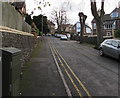
1

Fosterville Crescent houses, Abergavenny
Fosterville Crescent is on the east side of the A40 Monmouth Road.
Image: © Jaggery
Taken: 31 Dec 2017
0.01 miles
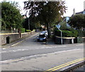
2
Fosterville Crescent, Abergavenny
Viewed from the corner of Holywell Road looking past a BT telecoms cabinet.
Image: © Jaggery
Taken: 31 Dec 2017
0.02 miles
3

Holywell Road East, Abergavenny
Viewed from Holywell Road. Holywell Road East leads to houses in Holywell Close, Holywell Crescent and Belmont Crescent.
Image: © Jaggery
Taken: 1 Jul 2012
0.02 miles
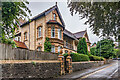
4
Yellow brick semis, Fosterville Crescent, Abergavenny
Semi-detached houses opposite a bend in Fosterville Crescent.
Image: © Jaggery
Taken: 31 Dec 2017
0.03 miles
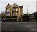
5
18 - 19 Fosterville Crescent
Pair of large semi-detached houses dating from the c.1890s. Grade II listed - see https://cadwpublic-api.azurewebsites.net/reports/listedbuilding/FullReport?lang=&id=86882 and https://cadwpublic-api.azurewebsites.net/reports/listedbuilding/FullReport?lang=&id=86885 respectively.
Image: © Ian Capper
Taken: 9 Sep 2021
0.03 miles
6
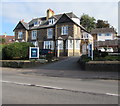
Lodge Dental, 10 Monmouth Road, Abergavenny
Private dental practice viewed across the A40.
Image: © Jaggery
Taken: 18 Oct 2018
0.04 miles
7
Holy well on Holywell Road
This is the site of the well which gives rise to the name of the road. The metal plaque announces the involvement of Abergavenny Civic Society in its restoration.
Image: © Alan Bowring
Taken: 7 Apr 2016
0.04 miles
8
Up Fosterville Crescent, Abergavenny
Fosterville Crescent ascends from the corner of the A40 Monmouth Road,
one of two junctions of these roads. The other one is 130 metres to the north.
Image: © Jaggery
Taken: 31 Dec 2017
0.04 miles
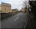
9
Junction of Monmouth Road and Fosterville Crescent, Abergavenny
Fosterville Crescent ascends from the A40 Monmouth Road.
A dark green telecoms cabinet is on the left.
Another dark green one, of a different design, is on the right.
Image: © Jaggery
Taken: 18 Oct 2018
0.04 miles
10

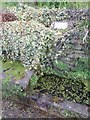
Ordnance Survey Cut Mark
This OS cut mark can be found on the wall SE side of Holywell Road. It marks a point 54.441m above mean sea level.
Image: © Adrian Dust
Taken: 23 Sep 2022
0.05 miles