IMAGES TAKEN NEAR TO
Mulberry Close, NP7 5ES
Introduction
This page details the photographs taken nearby to Mulberry Close, NP7 5ES by members of the Geograph project.
The Geograph project started in 2005 with the aim of publishing, organising and preserving representative images for every square kilometre of Great Britain, Ireland and the Isle of Man.

There are currently over 7.5m images from over14,400 individuals and you can help contribute to the project by visiting https://www.geograph.org.uk
Image Map
Images are licensed for reuse under creativecommons.org/licenses/by-sa/2.0
Notes
- Clicking on the map will re-center to the selected point.
- The higher the marker number, the further away the image location is from the centre of the postcode.
Image Listing (209 Images Found)
Images are licensed for reuse under creativecommons.org/licenses/by-sa/2.0
Image
Details
Distance
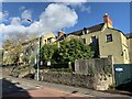
1
Ordnance Survey Cut Mark
This OS cut mark can be found on No139 Park Crescent. It marks a point 66.937m above mean sea level.
Image: © Adrian Dust
Taken: 3 Jul 2020
0.02 miles
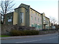
3
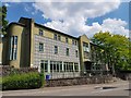
Former Ty'r Moerwydd Centre
Next door to the right of this photograph is a 17th century house named Ty'r Moerwydd or House of the Birch which has been listed by Cadw. In 1904 it became a convent for Breton nuns who opened a girls school. In 1956 this imptressive extension was added to the school. It later became an Outdoor Education Centre owned by a London Borough until it closed a number of years ago. Its future is undecided though new houses are being constructed to the rear in the former open space and car park.
Image: © Colin Cheesman
Taken: 25 Jun 2020
0.05 miles
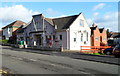
4
Penyfal Road, Abergavenny
Towards Skirrid Road and Park Crescent. Concrete posts https://www.geograph.org.uk/photo/6358020 are near the camera.
Image: © Jaggery
Taken: 29 Dec 2019
0.05 miles
5
Ty'r Morwydd (St Michael's Convent)
Category II listed. Listing reference 2469.
The house became a Convent of Breton nuns in 1906 and they ran a girls school for many years.
Image: © Andrew Abbott
Taken: 30 Oct 2021
0.06 miles
6
Abergavenny Labour Hall
Abergavenny Labour Hall and Institute is located at 110 Park Crescent.
Image: © Jaggery
Taken: 7 Dec 2011
0.06 miles
7

Afon Cibi, Abergavenny
The Afon Cibi here flows along the eastern edge of Pen-y-pound. The stream is a tributary of the River Gavenny into which it flows about 100 metres from the confluence of the Gavenny and the Usk, about a kilometre SE of here.
Image: © Jaggery
Taken: 7 Dec 2011
0.06 miles
8
Mulberry House, Abergavenny
Residential conference centre located on Pen-y-pound, facing The Tollhouse. http://www.geograph.org.uk/photo/2745162
Image: © Jaggery
Taken: 7 Dec 2011
0.06 miles
9
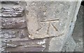
Ordnance Survey Cut Mark
This OS cut mark can be found on the gatepost of The Cloisters, Hill Road. It marks a point 66.836m above mean sea level.
Image: © Adrian Dust
Taken: 3 Jul 2020
0.07 miles
10
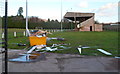
Stand, Pen-y-pound Stadium, Abergavenny
Viewed from an open gate at the edge of Pen-y-pound. The stand faces the south side of the pitch at Pen-y-pound Stadium, http://www.geograph.org.uk/photo/2799795 the home ground of Abergavenny Thursday Association Football Club.
Image: © Jaggery
Taken: 7 Dec 2011
0.09 miles