IMAGES TAKEN NEAR TO
St. Michaels Road, ABERGAVENNY, NP7 5AY
Introduction
This page details the photographs taken nearby to St. Michaels Road, NP7 5AY by members of the Geograph project.
The Geograph project started in 2005 with the aim of publishing, organising and preserving representative images for every square kilometre of Great Britain, Ireland and the Isle of Man.

There are currently over 7.5m images from over14,400 individuals and you can help contribute to the project by visiting https://www.geograph.org.uk
Image Map
Images are licensed for reuse under creativecommons.org/licenses/by-sa/2.0
Notes
- Clicking on the map will re-center to the selected point.
- The higher the marker number, the further away the image location is from the centre of the postcode.
Image Listing (367 Images Found)
Images are licensed for reuse under creativecommons.org/licenses/by-sa/2.0
Image
Details
Distance
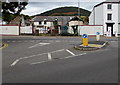
1
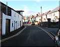
West along St Michael's Road, Abergavenny
Dead-end road connecting with the A40 behind camera.
Image: © Jaggery
Taken: 29 Dec 2019
0.03 miles
2
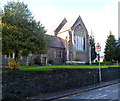
Grade II* listed Priory Church of Our Lady and Saint Michael, Abergavenny
Roman Catholic church on the west side of Pen-y-pound.
The foundation stone was laid on May 19th 1858. The Benedictine Bishop of Newport, Thomas Joseph Brown, opened the church on May 15th 1860. Grade II* listed in January 1974.
Image: © Jaggery
Taken: 7 Dec 2011
0.03 miles
3
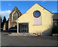
St Michael's Centre, Abergavenny
Located near the Grade II* listed Priory Church of Our Lady and Saint Michael, http://www.geograph.org.uk/photo/2745104 part of which is in the background.
St Michael's Centre is a community centre for community activities, education, training, clubs, meetings, weddings and social events. Facilities available include catering, licensed bar and a computer-equipped training room. The centre is funded by a combination of public funds and profits generated by the business activities of the centre.
Image: © Jaggery
Taken: 7 Dec 2011
0.03 miles
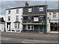
4
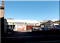
Heronhurst, Abergavenny
Windows and doors retailer at 33-35 Brecon Road.
Image: © Jaggery
Taken: 7 Feb 2014
0.04 miles
5
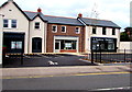
H. Shackleton Pharmacy, 33 Brecon Road, Abergavenny
In newly-built premises on the north side of the A40 Brecon Road viewed on September 30th 2018.
A May 2018 Google Earth Street View shows a fenced-off building site here with these buildings under scaffolding.
Image: © Jaggery
Taken: 30 Sep 2018
0.04 miles
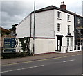
6
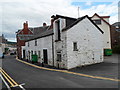
St Michael's Road, Abergavenny
Looking towards the A40.
The whitewashed building has two doors, one at street level, the other at first floor level.
Image: © Jaggery
Taken: 15 Jul 2012
0.04 miles
7
H.Shackleton Pharmacy name on a Brecon Road side wall, Abergavenny
A few metres from the pharmacy. https://www.geograph.org.uk/photo/5990842
Image: © Jaggery
Taken: 29 Dec 2019
0.04 miles
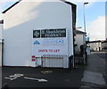
8
Scaffolding on Trelough House, 13 Brecon Road, Abergavenny
Viewed from the corner of Merthyr Road on September 30th 2018.
Image: © Jaggery
Taken: 30 Sep 2018
0.04 miles
9
Junction of Merthyr Road and Brecon Road, Abergavenny
Merthyr Road joins the A40 Brecon Road.
Image: © Jaggery
Taken: 30 Sep 2018
0.05 miles
10
Direction and distances signs, Brecon Road, Abergavenny
On the north side of the A40 Brecon Road facing the Merthyr Road junction.
Left for Brecon (20 miles), right for Monmouth (16), Hereford (22), Cwmbran (14), Newport (18).
The Welsh names for Brecon, Monmouth and Newport are also shown.
Image: © Jaggery
Taken: 30 Sep 2018
0.05 miles