IMAGES TAKEN NEAR TO
Lower Cwm Nant Gam, ABERGAVENNY, NP7 0RG
Introduction
This page details the photographs taken nearby to Lower Cwm Nant Gam, NP7 0RG by members of the Geograph project.
The Geograph project started in 2005 with the aim of publishing, organising and preserving representative images for every square kilometre of Great Britain, Ireland and the Isle of Man.

There are currently over 7.5m images from over14,400 individuals and you can help contribute to the project by visiting https://www.geograph.org.uk
Image Map
Images are licensed for reuse under creativecommons.org/licenses/by-sa/2.0
Notes
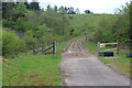
- Clicking on the map will re-center to the selected point.
- The higher the marker number, the further away the image location is from the centre of the postcode.
Image Listing (26 Images Found)
Images are licensed for reuse under creativecommons.org/licenses/by-sa/2.0
Image
Details
Distance
1
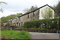
Houses on Buttercup Lane, Cwm Nant-gam
The end of a row of houses not far from the end of the lane, down behind camera.
Image: © M J Roscoe
Taken: 7 May 2023
0.01 miles
2
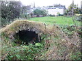
Old lime kiln
Old remnant of what I presume was an old lime kiln.
Image: © Jeremy Bolwell
Taken: 3 Nov 2012
0.03 miles
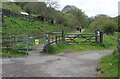
3
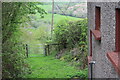
Public footpath by School House
Gated path down towards Greenfield Cottage.
Image: © M J Roscoe
Taken: 7 May 2023
0.06 miles
4
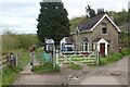
Crossing Cottage by former railway, Cwm Nant-gam
NCR 46 goes east via kissing gate on the former railway trackbed of the Merthyr Tredegar & Abergavenny Railway.
Image: © M J Roscoe
Taken: 7 May 2023
0.06 miles
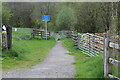
5
NCR 46, Cwm Nant-gam
Cycle and pedestrian path on trackbed of former railway at former crossing, opposite Crossing Cottage Image; to the right a bridle path Image leaves the end of the highway, Buttercup Lane.
Image: © M J Roscoe
Taken: 7 May 2023
0.08 miles
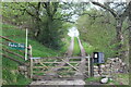
6
Bridle path down to footbridge over A465
The bilingual blue sign says, 'No through route for equestrians', presumably because there are steps up to the bridge Image
Image: © M J Roscoe
Taken: 7 May 2023
0.08 miles
8
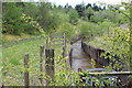
Drainage channel, Cwm Nant-gam
Man-made watercourse draining old coal workings. The water goes under the road (camera position) in to a long culvert.
Image: © M J Roscoe
Taken: 7 May 2023
0.11 miles
9
Start of muddy track up to cycle route
The track, wrongly shown on OS map as NCR 46, heads to NCR 492 on Mynydd Rheinallt.
Image: © M J Roscoe
Taken: 7 May 2023
0.13 miles
10
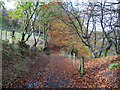
Path in Cwm Clydach
Now looking quite autumnal.
Image: © Jeremy Bolwell
Taken: 3 Nov 2012
0.14 miles