IMAGES TAKEN NEAR TO
Railway Side, ABERGAVENNY, NP7 0RD
Introduction
This page details the photographs taken nearby to Railway Side, NP7 0RD by members of the Geograph project.
The Geograph project started in 2005 with the aim of publishing, organising and preserving representative images for every square kilometre of Great Britain, Ireland and the Isle of Man.

There are currently over 7.5m images from over14,400 individuals and you can help contribute to the project by visiting https://www.geograph.org.uk
Image Map
Images are licensed for reuse under creativecommons.org/licenses/by-sa/2.0
Notes
- Clicking on the map will re-center to the selected point.
- The higher the marker number, the further away the image location is from the centre of the postcode.
Image Listing (27 Images Found)
Images are licensed for reuse under creativecommons.org/licenses/by-sa/2.0
Image
Details
Distance
1
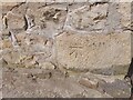
Ordnance Survey Cut Mark
This OS cut mark can be found on No1 Hileys Row. It marks a point 177.049m above mean sea level.
Image: © Adrian Dust
Taken: 9 Jun 2023
0.11 miles
3
Old limestone quarry above Clydach
Former quarry associated with the old Clydach Lime Works. What could be an attractive view is spoiled by the amount of rubbish which has been tipped over the edge.
Image: © Gordon Hatton
Taken: 2 Sep 2013
0.14 miles
4
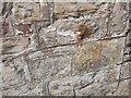
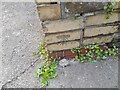
Ordnance Survey Cut Mark
This OS cut mark can be found on the Cambrian Inn. It marks a point 195.276m above mean sea level.
Image: © Adrian Dust
Taken: 9 Jun 2023
0.17 miles
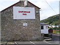
5
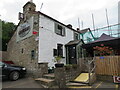
The Cambrian Inn
Halfway up, or halfway down the hill in Clydach village.
Image: © Gordon Hatton
Taken: 19 Sep 2022
0.17 miles
6
Ordnance Survey Cut Mark
This OS cut mark can be found on the gatepost of Blantyre. It marks a point 155.978m above mean sea level.
Image: © Adrian Dust
Taken: 9 Jun 2023
0.17 miles
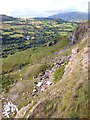
7
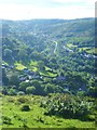
View over Clydach
The view across the Clydach gorge with the A465 Heads of the Valleys road snaking its way up the valley.
Image: © Gordon Hatton
Taken: 2 Sep 2013
0.17 miles
8
Former railway viaduct at Clydach
Now part of a cycle and walkway, the viaduct spans a deep side valley above the village of Clydach.
Image: © Gordon Hatton
Taken: 19 Sep 2022
0.17 miles
9
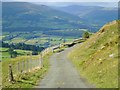
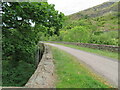
Scenic road above Clydach
The minor road which curves around the west and north side of Gilwern Hill affords fine views towards the Usk valley and distant Black Mountains.
Image: © Gordon Hatton
Taken: 2 Sep 2013
0.17 miles
10
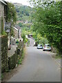
Station Road, Clydach
A very steep hill (25%) leading down through Clydach village from the site of the former railway station.
Image: © Gordon Hatton
Taken: 19 Sep 2022
0.18 miles