IMAGES TAKEN NEAR TO
Upper Gellifelen, Llanelly Hill, ABERGAVENNY, NP7 0NY
Introduction
This page details the photographs taken nearby to NP7 0NY by members of the Geograph project.
The Geograph project started in 2005 with the aim of publishing, organising and preserving representative images for every square kilometre of Great Britain, Ireland and the Isle of Man.

There are currently over 7.5m images from over14,400 individuals and you can help contribute to the project by visiting https://www.geograph.org.uk
Image Map
Images are licensed for reuse under creativecommons.org/licenses/by-sa/2.0
Notes
- Clicking on the map will re-center to the selected point.
- The higher the marker number, the further away the image location is from the centre of the postcode.
Image Listing (15 Images Found)
Images are licensed for reuse under creativecommons.org/licenses/by-sa/2.0
Image
Details
Distance
1
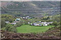
Houses on hillside, Cwm Clydach
The small house in the centre is Holly Tree Cottage with Windy Ridge to its right.
Image: © M J Roscoe
Taken: 7 May 2023
0.11 miles
2
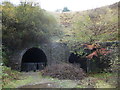
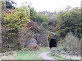
Old railway tunnels at Gellifelin in the Clydach Gorge
Sadly by-passed by the national cycleroute and footpath but hardly visitor proof. The railway here was the defunct Merthyr, Tredegar & Abergavenny Railway which ran up this gorge between 1862 and 1958. Just one of several amazing early engineering feats accomplished to enable the railway to run here.
Image: © Jeremy Bolwell
Taken: 3 Nov 2012
0.14 miles
3
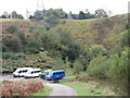
West end of Gelli-Felen tunnel
The tunnel portals are now obscured by trees, but are located just behind the minibuses.
Image: © Gareth James
Taken: 15 Oct 2011
0.15 miles
4
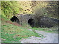
Clydach tunnels
The twin entrances to the tunnels under Gellifelen on the former railway running down (up?) the Clydach Gorge between Abergavenny and Brymawr. The National Cycle Network route 46 skirts the hill to the left to avoid passing through the tunnels.
Image: © Alan Bowring
Taken: 21 Apr 2007
0.16 miles
5
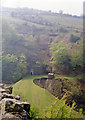
Eastern portals of Gelli-Felen tunnel
The southern of the former railway tunnels is blocked, whereas the northern one is not. The cyclepath swings to the right, following the route of Bailey's 1821 tramroad.
Image: © Gareth James
Taken: 15 Oct 2011
0.19 miles
6
Site of Clydach station, 1988
View SW, towards Brynmawr and Merthyr: ex-LNWR Abergavenny Junction - Brynmawr - Merthyr line, the celebrated Heads of Valleys line, all closed 6/1/58. (See also Image]).
Image: © Ben Brooksbank
Taken: 8 May 1988
0.20 miles
7
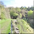
Old railway trackbed, Clydach Gorge
The entrance portals to Gellifelen tunnel are just visible, the lefthand one is bricked up.
Image: © Flying Stag
Taken: 12 May 2012
0.21 miles
8
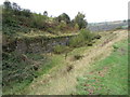
Former railway cutting near Gelli-Felen halt
Image: © Gareth James
Taken: 15 Oct 2011
0.23 miles
9
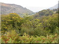
Autumn in the Clydach Gorge
http://www.geograph.org.uk/photo/2636378
Image: © Gareth James
Taken: 15 Oct 2011
0.23 miles
10
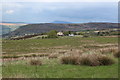
Rough grassland north of Blaenafon Road
View northeast from B4248, part of the Brecon Beacons National Park, with enclosed and open access land.
Image: © M J Roscoe
Taken: 9 May 2019
0.23 miles