IMAGES TAKEN NEAR TO
The Shires, ABERGAVENNY, NP7 0EX
Introduction
This page details the photographs taken nearby to The Shires, NP7 0EX by members of the Geograph project.
The Geograph project started in 2005 with the aim of publishing, organising and preserving representative images for every square kilometre of Great Britain, Ireland and the Isle of Man.

There are currently over 7.5m images from over14,400 individuals and you can help contribute to the project by visiting https://www.geograph.org.uk
Image Map
Images are licensed for reuse under creativecommons.org/licenses/by-sa/2.0
Notes
- Clicking on the map will re-center to the selected point.
- The higher the marker number, the further away the image location is from the centre of the postcode.
Image Listing (17 Images Found)
Images are licensed for reuse under creativecommons.org/licenses/by-sa/2.0
Image
Details
Distance
1
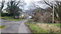
Gilwern Lower Common
Lower Common is an extension to Gilwern village on the Usk Valley floor.
Image: © Jonathan Billinger
Taken: 5 Feb 2015
0.08 miles
2
Lower Common; house and cat
The moggie was watching me carefully!
Lower Common is an extension to Gilwern village on the Usk Valley floor.
Image: © Jonathan Billinger
Taken: 5 Feb 2015
0.10 miles
3
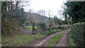
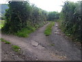
Lower Common, Gilwern
This lane runs through one of two pieces of common land in the village of Gilwern.
Image: © Alan Bowring
Taken: 9 Jul 2007
0.11 miles
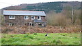
4
Maes-y-berllan
Farm on the Usk Valley floor at Gilwern Lower Common.
Image: © Jonathan Billinger
Taken: 5 Feb 2015
0.14 miles
5
Kennelwood, Gilwern
From the north side of Cae Meldon, Kennelwood leads to Elm Grove, Lower Common and Kennel Wood.
Image: © Jaggery
Taken: 13 Aug 2017
0.14 miles
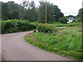
6
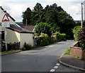
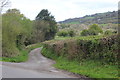
A very minor road
Lane from Lower Common that winds its way towards the Usk Bridge.
Image: © Jonathan Billinger
Taken: 5 Feb 2015
0.15 miles
7
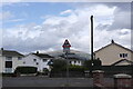
West along Cae Meldon, Gilwern
Viewed from the Kennelwood/New School Road crossroads.
A bilingual sign warns of humps for 95 yards and the Welsh equivalent.
Image: © Jaggery
Taken: 13 Aug 2017
0.20 miles
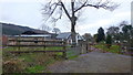
8
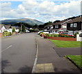
Cae Meldon Crossroads
Crossroads at the bottom of the village of Gilwern just around the corner from the local primary school. The mountain Pen Cerrig-calch can be seen in the background.
Image: © Luke Jones
Taken: 23 Aug 2022
0.20 miles
9
Minor road, Gilwern
Field entrance to the left and a public road off to the right - not much difference at first glance. The road appears more of a thoroughfare on the map than it does on the ground. It leads to Lower Common.
Image: © Alan Bowring
Taken: 9 Jul 2007
0.21 miles
10
Lane to Maes-y-berllan
Start of minor narrow road from Glangrwney Road near the River Usk.
Image: © M J Roscoe
Taken: 10 Apr 2017
0.21 miles