IMAGES TAKEN NEAR TO
Glangrwyney Road, ABERGAVENNY, NP7 0EG
Introduction
This page details the photographs taken nearby to Glangrwyney Road, NP7 0EG by members of the Geograph project.
The Geograph project started in 2005 with the aim of publishing, organising and preserving representative images for every square kilometre of Great Britain, Ireland and the Isle of Man.

There are currently over 7.5m images from over14,400 individuals and you can help contribute to the project by visiting https://www.geograph.org.uk
Image Map
Images are licensed for reuse under creativecommons.org/licenses/by-sa/2.0
Notes
- Clicking on the map will re-center to the selected point.
- The higher the marker number, the further away the image location is from the centre of the postcode.
Image Listing (45 Images Found)
Images are licensed for reuse under creativecommons.org/licenses/by-sa/2.0
Image
Details
Distance
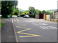
1
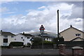
Cae Meldon Crossroads
Crossroads at the bottom of the village of Gilwern just around the corner from the local primary school. The mountain Pen Cerrig-calch can be seen in the background.
Image: © Luke Jones
Taken: 23 Aug 2022
0.11 miles
2
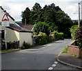
West along Cae Meldon, Gilwern
Viewed from the Kennelwood/New School Road crossroads.
A bilingual sign warns of humps for 95 yards and the Welsh equivalent.
Image: © Jaggery
Taken: 13 Aug 2017
0.12 miles
3
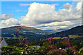
Towpath view, Mon and Brec at Gilwern
The Brecon and Abergavenny Canal was authorised in 1793 and was built in three stages; the northern stage from Brecon in 1796-1800 by engineer Thomas Dadford Jnr, the section from Gilwern to Llanfoist in 1802-5 by Thomas Cartwright and the route from Llanfoist to Pontymoile in 1809-12 by William Crosley. The various sections came under one ownership
in 1865 and became known as the Monmouthshire and Brecon Canal, or ‘Mon and Brec’ as canal folk would have it.
The tree lined canal follows contours and affords grand views from the towpath at Gilwern of the Black Mountains, which today look benign and welcoming.
Image: © Philip Pankhurst
Taken: 12 Aug 2017
0.14 miles
4
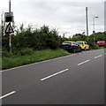
Your Speed indicator, Crickhowell Road, Gilwern
Currently off, the display turns on to show the speed in green if an approaching
vehicle is within the speed limit (30mph), or in red if over the speed limit.
Image: © Jaggery
Taken: 20 Aug 2017
0.17 miles
5
Zigzag markings on New School Road, Gilwern
Marking the Keep Clear Zone at the edge of the road into Gilwern Primary School. ARAF is Welsh for SLOW
Image: © Jaggery
Taken: 13 Aug 2017
0.17 miles
6
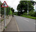
Warning sign - elderly people, Crickhowell Road, Gilwern
The stereotypical depiction of the elderly faces traffic heading northwestwards on the A4077 Crickhowell Road.
Image: © Jaggery
Taken: 20 Aug 2017
0.17 miles
7
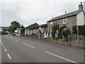
Old School House, Crickhowell Road, Gilwern
Centre left, the single-storey former school in the northwest of Gilwern was built c1845.
Image: © Jaggery
Taken: 20 Aug 2017
0.17 miles
8
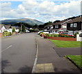
Kennelwood, Gilwern
From the north side of Cae Meldon, Kennelwood leads to Elm Grove, Lower Common and Kennel Wood.
Image: © Jaggery
Taken: 13 Aug 2017
0.17 miles
9
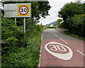
Start of the 30 zone at the northwest edge of Gilwern
The National Speed Limit on the A4077 Crickhowell Road drops to 30mph.
Image: © Jaggery
Taken: 20 Aug 2017
0.17 miles
10
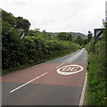
End of the 30 zone beyond the northwest edge of Gilwern
The 30mph speed limit on the A4077 Crickhowell Road increases to the National Speed Limit beyond Gilwern.
Image: © Jaggery
Taken: 20 Aug 2017
0.17 miles