IMAGES TAKEN NEAR TO
Aberbaiden, ABERGAVENNY, NP7 0EF
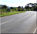
Introduction
This page details the photographs taken nearby to Aberbaiden, NP7 0EF by members of the Geograph project.
The Geograph project started in 2005 with the aim of publishing, organising and preserving representative images for every square kilometre of Great Britain, Ireland and the Isle of Man.

There are currently over 7.5m images from over14,400 individuals and you can help contribute to the project by visiting https://www.geograph.org.uk
Image Map (Loading...)


Getting Data...Please wait
Leaflet Map data © OpenStreetMap
Images are licensed for reuse under creativecommons.org/licenses/by-sa/2.0
Notes
- Clicking on the map will re-center to the selected point.
- The higher the marker number, the further away the image location is from the centre of the postcode.
Image Listing (51 Images Found)
Images are licensed for reuse under creativecommons.org/licenses/by-sa/2.0
Image
Details
Distance
1
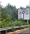
Sign on the approach to Glanbaiden Roundabout, Gilwern, Monmouthshire
The sign alongside an exit slip road from the A465 Heads of the
Valleys Road shows that Glanbaiden is Glanbaedan in Welsh.
Image: © Jaggery
Taken: 17 Sep 2023
0.04 miles
2
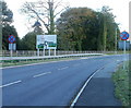
A4077 from Gilwern approaches Heads of the Valleys roundabout
Abergavenny Road (A4077) approaches its eastern end at the A465 (Heads of the Valleys) roundabout ahead. The road east to Abergavenny continues on the far side of the roundabout, downgraded to a B road (B4246) and renamed Merthyr Road.
Image: © Jaggery
Taken: 20 Oct 2010
0.04 miles
3
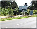
A4077 directions sign east of Gilwern
Facing eastbound traffic on the A4077 Abergavenny Road on the approach to the A465 Heads of the Valleys Road junction. Access to the B4246 towards Govilon and Llanfoist is also at the junction ahead.
Image: © Jaggery
Taken: 13 Aug 2017
0.05 miles
4
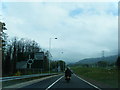
Heads of the Valleys Road nears Crickhowell junction roundabout
Image: © Colin Pyle
Taken: 7 May 2012
0.06 miles
5
Abergavenny Road leaves Gilwern
The A4077 Abergavenny Road passes the grey back of the Gilwern boundary/welcome sign. http://www.geograph.org.uk/photo/5497560
The A4077 ends at the A465 Heads of the Valleys Road junction out of shot ahead.
Image: © Jaggery
Taken: 13 Aug 2017
0.07 miles
6
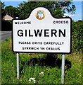
Gilwern boundary sign
On the right here. http://www.geograph.org.uk/photo/5497547 Gilwern is a village in Monmouthshire about 6 km west of Abergavenny.
The Llanelly Community Council emblem is depicted on the sign.
Image: © Jaggery
Taken: 13 Aug 2017
0.09 miles
7
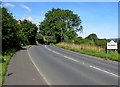
Eastern boundary of Gilwern
The A4077 Abergavenny Road enters Gilwern, a village in Monmouthshire.
http://www.geograph.org.uk/photo/5497560 to a closer view of the boundary/welcome sign.
Image: © Jaggery
Taken: 13 Aug 2017
0.09 miles
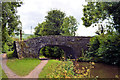
8
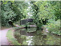
Bridge 102
A rather asymmetric bridge, higher on the left to accommodate the towing path.
Image: © Gordon Hatton
Taken: 19 Sep 2022
0.10 miles
9
Southern side of Heads of the Valleys Road (A465) roundabout
Viewed from the B4246 (Merthyr Road). On the far side of the roundabout, out of shot, is the A4077, for Gilwern and Crickhowell.
Image: © Jaggery
Taken: 20 Oct 2010
0.10 miles
10
Heol-yr-Allt Bridge, No 101
Between Gilwern and Govilon.
Image: © Philip Pankhurst
Taken: 12 Aug 2017
0.11 miles