IMAGES TAKEN NEAR TO
The Halfpennys, ABERGAVENNY, NP7 0EA
Introduction
This page details the photographs taken nearby to The Halfpennys, NP7 0EA by members of the Geograph project.
The Geograph project started in 2005 with the aim of publishing, organising and preserving representative images for every square kilometre of Great Britain, Ireland and the Isle of Man.

There are currently over 7.5m images from over14,400 individuals and you can help contribute to the project by visiting https://www.geograph.org.uk
Image Map
Images are licensed for reuse under creativecommons.org/licenses/by-sa/2.0
Notes
- Clicking on the map will re-center to the selected point.
- The higher the marker number, the further away the image location is from the centre of the postcode.
Image Listing (17 Images Found)
Images are licensed for reuse under creativecommons.org/licenses/by-sa/2.0
Image
Details
Distance
1
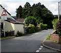
West along Cae Meldon, Gilwern
Viewed from the Kennelwood/New School Road crossroads.
A bilingual sign warns of humps for 95 yards and the Welsh equivalent.
Image: © Jaggery
Taken: 13 Aug 2017
0.09 miles
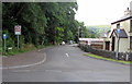
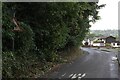
2
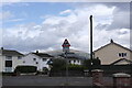
Cae Meldon Crossroads
Crossroads at the bottom of the village of Gilwern just around the corner from the local primary school. The mountain Pen Cerrig-calch can be seen in the background.
Image: © Luke Jones
Taken: 23 Aug 2022
0.09 miles
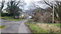
3
Kennelwood, Gilwern
From the north side of Cae Meldon, Kennelwood leads to Elm Grove, Lower Common and Kennel Wood.
Image: © Jaggery
Taken: 13 Aug 2017
0.09 miles
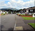
4
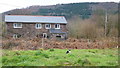
Gilwern Lower Common
Lower Common is an extension to Gilwern village on the Usk Valley floor.
Image: © Jonathan Billinger
Taken: 5 Feb 2015
0.09 miles
5
Lower Common; house and cat
The moggie was watching me carefully!
Lower Common is an extension to Gilwern village on the Usk Valley floor.
Image: © Jonathan Billinger
Taken: 5 Feb 2015
0.11 miles
6
New School Road, Gilwern
From Cae Meldon south along one-way New School Road towards Gilwern Primary School.
Image: © Jaggery
Taken: 13 Aug 2017
0.13 miles
7
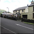
New School Road houses, Gilwern
The white arrow shows the direction of travel for vehicles on this one-way road.
Image: © Jaggery
Taken: 13 Aug 2017
0.14 miles
8
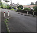
Traffic calming, New School Road, Gilwern
The road width is reduced for a few metres on the approach to Gilwern Primary School.
Image: © Jaggery
Taken: 13 Aug 2017
0.14 miles
9
Crossroads Sign, Gilwern
Old Crossroads sign for incoming crossroad between Cae Meldon, Kennelwood and New School Rd. The sign uses the original design for the crossroad warning sign from between 1965 and 1975. The design was revised in the 1975 TSRGD to make the priority road pointed and slightly thicker.
Image: © Luke Jones
Taken: 23 Aug 2022
0.15 miles
10
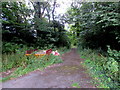
Road into Upper Common, Gilwern
From the east side of New School Road.
Image: © Jaggery
Taken: 13 Aug 2017
0.15 miles