IMAGES TAKEN NEAR TO
Church Road, ABERGAVENNY, NP7 0BX
Introduction
This page details the photographs taken nearby to Church Road, NP7 0BX by members of the Geograph project.
The Geograph project started in 2005 with the aim of publishing, organising and preserving representative images for every square kilometre of Great Britain, Ireland and the Isle of Man.

There are currently over 7.5m images from over14,400 individuals and you can help contribute to the project by visiting https://www.geograph.org.uk
Image Map
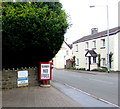
Images are licensed for reuse under creativecommons.org/licenses/by-sa/2.0
Notes
- Clicking on the map will re-center to the selected point.
- The higher the marker number, the further away the image location is from the centre of the postcode.
Image Listing (203 Images Found)
Images are licensed for reuse under creativecommons.org/licenses/by-sa/2.0
Image
Details
Distance
1
SORRY NO FUEL notice facing Crickhowell Road, Gilwern
At the edge of this http://www.geograph.org.uk/photo/5500452 filling station in August 2017.
Image: © Jaggery
Taken: 13 Aug 2017
0.01 miles
2
Gilwern Stores and post office, Gilwern
In August 2017, the village post office is inside this convenience store alongside the A4077 Crickhowell Road.
A banner shows Your brand new One Stop convenience store is taking shape.
All three pumps in the adjacent Harvest Energy filling station are not in use today.
A nearby notice shows SORRY NO FUEL. http://www.geograph.org.uk/photo/5500465
I don't know whether this is a temporary or permanent closure of the filling station.
Image: © Jaggery
Taken: 13 Aug 2017
0.01 miles
3
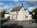
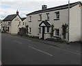
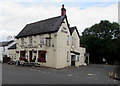
Corn Exchange, Gilwern
Pub on the corner of Crickhowell Road and Glangrwyney Road, viewed from the corner of Church Road.
Image: © Jaggery
Taken: 20 Oct 2010
0.02 miles
4
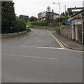
Junction of Church Road and Crickhowell Road, Gilwern
Church Road ascends from the A4077 Crickhowell Road. Signs on the right show that
Llanelly Church is 1½ miles ahead and Church Road is unsuitable for heavy goods vehicles.
Image: © Jaggery
Taken: 20 Aug 2017
0.02 miles
5
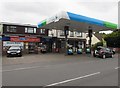
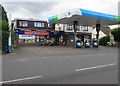
Harvest Energy, Crickhowell Road, Gilwern
On Sunday August 20th 2017, all three fuel pumps at Harvest Energy are out of use.
Gilwern Stores and Post Office are on the left.
Image: © Jaggery
Taken: 20 Aug 2017
0.02 miles
6
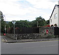
Wall-mounted postbox, Crickhowell Road, Gilwern
Near the corner of Glangrwyney Road.
Image: © Jaggery
Taken: 13 Aug 2017
0.02 miles
7
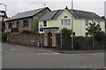
Houses on a Gilwern corner
The house on the left faces Church Road, next door to Magnolia House on the corner of Crickhowell Road.
Image: © Jaggery
Taken: 20 Aug 2017
0.02 miles
8
Crickhowell Road house near the Corn Exchange, Gilwern
The Corn Exchange pub http://www.geograph.org.uk/photo/5500443 is on the left.
Image: © Jaggery
Taken: 13 Aug 2017
0.02 miles
9
Corn Exchange, Gilwern
Pub on the corner of the A4077 Crickhowell Road and Glangrwyney Road
(ahead on the right), viewed from the corner of Church Road.
Image: © Jaggery
Taken: 13 Aug 2017
0.03 miles
10
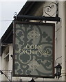
Corn Exchange name sign, Gilwern
Hanging from a wall bracket here. http://www.geograph.org.uk/photo/5505895
Image: © Jaggery
Taken: 20 Aug 2017
0.03 miles