1
Brynglas, Gilwern
From Common Road, Brynglas leads to Dan-y-bryn.
Image: © Jaggery
Taken: 13 Aug 2017
0.04 miles
2
When Saturday comes in Gilwern ...
The noise of a partisan crowd at a local football match could be heard from the canal towpath and can just about be seen in the picture. No goals were scored, but the ref seemed to be far from popular.
Image: © Philip Pankhurst
Taken: 12 Aug 2017
0.04 miles
3
Glanmoor, Gilwern
Glanmoor (Glanrhos in Welsh) is a cul-de-sac on the east side of Common Road.
Image: © Jaggery
Taken: 13 Aug 2017
0.05 miles
4
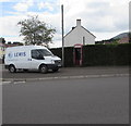
No longer a phonebox, Common Road, Gilwern
The phoneless doorless former phonebox is in a hedge near the corner of Brynglas. Viewed in August 2017.
Image: © Jaggery
Taken: 13 Aug 2017
0.08 miles
5
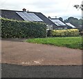
Rooftop solar panels, Gilwern, Monmouthshire
Suboptimally located on east-facing roofs.
Image: © Jaggery
Taken: 17 Sep 2023
0.08 miles
6
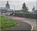
Down Common Road, Gilwern
Viewed from near the Crickhowell Road junction, Common Road descends towards Gilwern Common.
Image: © Jaggery
Taken: 13 Aug 2017
0.09 miles
7
Broadmead, Gilwern
Broadmead heads away from the north side of Abergavenny Road. Wide signs on each side of the road show that Broadmead leads to Basildene Close, Llanwenarth View and Brynglas. In the distance is the high ground of Graig forest, with the peak of Pen-y-Graig (about 310 metres elevation) on the right.
Image: © Jaggery
Taken: 20 Oct 2010
0.09 miles
8
Common Road houses, Gilwern
On the west side of the road.
Image: © Jaggery
Taken: 13 Aug 2017
0.09 miles
9
Grassy area near bungalows in Gilwern
On the west side of Common Road.
Image: © Jaggery
Taken: 13 Aug 2017
0.10 miles
10
Warning sign - humps for ¼ mile, Broadmead, Gilwern, Monmouthshire
The text is also in Welsh.
Image: © Jaggery
Taken: 17 Sep 2023
0.11 miles


