IMAGES TAKEN NEAR TO
Crawshay Bailey Close, ABERGAVENNY, NP7 0AZ
Introduction
This page details the photographs taken nearby to Crawshay Bailey Close, NP7 0AZ by members of the Geograph project.
The Geograph project started in 2005 with the aim of publishing, organising and preserving representative images for every square kilometre of Great Britain, Ireland and the Isle of Man.

There are currently over 7.5m images from over14,400 individuals and you can help contribute to the project by visiting https://www.geograph.org.uk
Image Map
Images are licensed for reuse under creativecommons.org/licenses/by-sa/2.0
Notes
- Clicking on the map will re-center to the selected point.
- The higher the marker number, the further away the image location is from the centre of the postcode.
Image Listing (10 Images Found)
Images are licensed for reuse under creativecommons.org/licenses/by-sa/2.0
Image
Details
Distance
3
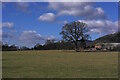
Cae Meldon Oak
Large Oak Tree near Cae Meldon, Northern Gilwern. Well, it's reasonable to assume it's Oak considering the nearby lane is called "Oak Tree Lane".
Image: © Luke Jones
Taken: 23 Feb 2023
0.14 miles
4
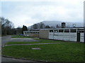
Entrance to Gilwern Outdoor education Centre
A slightly scruffy approach to the establishment based at Ty Mawr.
Image: © Jonathan Billinger
Taken: 5 Feb 2015
0.17 miles
5
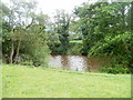
River Usk near Llanwenarth
At this point, the Usk is about 75 metres south of the A40. Viewed from the edge of this field. http://www.geograph.org.uk/photo/2481177
Image: © Jaggery
Taken: 19 Jun 2011
0.19 miles
6
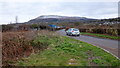
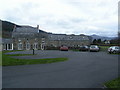
Road to Gilwern Lower Common
In the Usk valley just north of Gilwern village.
In the distance is Pen Cerrig-calch.
Image: © Jonathan Billinger
Taken: 5 Feb 2015
0.19 miles
7
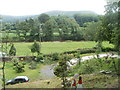
North bank of the River Usk, Llanwenarth
Viewed from the A40 near Mardy Cottage. The dark brown Usk flows across the middle of the view.
Image: © Jaggery
Taken: 19 Jun 2011
0.21 miles
8
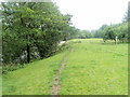
Riverbank track near Llanwenarth
A narrow track runs along the north bank of the River Usk, about 75 metres south of the A40.
Image: © Jaggery
Taken: 19 Jun 2011
0.22 miles
9
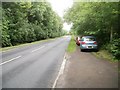
A40, Llanwenarth
Looking along the A40 in the direction of Abergavenny. The cars are parked near a stile leading to a field http://www.geograph.org.uk/photo/2481177 on the north bank of the River Usk.
Image: © Jaggery
Taken: 19 Jun 2011
0.24 miles
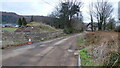
10
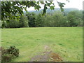
Riverside field, Llanwenarth
The view south from a stile at the edge of the A40. http://www.geograph.org.uk/photo/2481166
The line of trees are on the bank of the River Usk. http://www.geograph.org.uk/photo/2481194
Image: © Jaggery
Taken: 19 Jun 2011
0.24 miles