IMAGES TAKEN NEAR TO
Lancaster Drive, ABERGAVENNY, NP7 0AA
Introduction
This page details the photographs taken nearby to Lancaster Drive, NP7 0AA by members of the Geograph project.
The Geograph project started in 2005 with the aim of publishing, organising and preserving representative images for every square kilometre of Great Britain, Ireland and the Isle of Man.

There are currently over 7.5m images from over14,400 individuals and you can help contribute to the project by visiting https://www.geograph.org.uk
Image Map
Images are licensed for reuse under creativecommons.org/licenses/by-sa/2.0
Notes
- Clicking on the map will re-center to the selected point.
- The higher the marker number, the further away the image location is from the centre of the postcode.
Image Listing (38 Images Found)
Images are licensed for reuse under creativecommons.org/licenses/by-sa/2.0
Image
Details
Distance
1
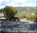
Crossroads leading to Lancaster Drive, Gilwern
There is plenty of scope for confusion here. The road ahead is named Crossroads, viewed from a T junction (not crossroads) with Abergavenny Road. And 150 metres east of here, a cul-de-sac named Cross Roads http://www.geograph.org.uk/photo/2122522 connects with the other side of Abergavenny Road. No doubt it is all perfectly clear to locals...
Image: © Jaggery
Taken: 20 Oct 2010
0.03 miles
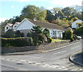
2
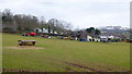
Bungalow and farm equipment
On the edge of the urban village of Gilwern.
Image: © Jonathan Billinger
Taken: 5 Feb 2015
0.06 miles
3
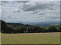
Usk valley panorama
Looking into Wales from a wildflower meadow west of the Wye valley
Blorenge - Brecon Beacons - Usk valley - Sugar Loaf - Black Mountains
Image: © Martin Laverty
Taken: 14 Jul 2016
0.08 miles
4
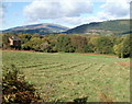
Field on the north side of Abergavenny Road, Gilwern
Looking towards a house at the edge of Broadmead.
Image: © Jaggery
Taken: 20 Oct 2010
0.09 miles
5
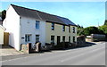
Crossroads Cottages, Gilwern
Short row of houses on the south side of the A4077 Abergavenny Road, between Greenwood Place and Usk Drive.
Image: © Jaggery
Taken: 13 Aug 2017
0.10 miles
6
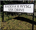
Bilingual name sign on a Gilwern corner
Facing Abergavenny Road, the sign shows that Usk Drive is Rhodfa'r Wysg in Welsh.
Image: © Jaggery
Taken: 13 Aug 2017
0.11 miles
7
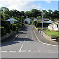
Greenwood Place, Gilwern
Cul-de-sac ascending from the south side of the A4077 Abergavenny Road.
The far end of Greenwood Place is on the north bank of the Monmouthshire & Brecon Canal.
Image: © Jaggery
Taken: 13 Aug 2017
0.11 miles
8
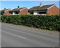
Basildene Close houses, Gilwern
Houses on the south side of Basildene Close viewed across an Abergavenny Road hedge.
Image: © Jaggery
Taken: 13 Aug 2017
0.11 miles
9
Corner of Abergavenny Road and Greenwood Place, Gilwern
The view across Abergavenny Road (A4077). Greenwood Place is a short cul-de-sac on the south side of the road.
Image: © Jaggery
Taken: 20 Oct 2010
0.12 miles
10
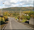
Greenwood Place, Gilwern
Looking down Greenwood Place towards the T junction with Abergavenny Road (A4077).
In the distance is the high ground of Graig forest and the peak of Pen-y-Graig.
Image: © Jaggery
Taken: 20 Oct 2010
0.12 miles