IMAGES TAKEN NEAR TO
Abergavenny Road, PONTYPOOL, NP4 9RG
Introduction
This page details the photographs taken nearby to Abergavenny Road, NP4 9RG by members of the Geograph project.
The Geograph project started in 2005 with the aim of publishing, organising and preserving representative images for every square kilometre of Great Britain, Ireland and the Isle of Man.

There are currently over 7.5m images from over14,400 individuals and you can help contribute to the project by visiting https://www.geograph.org.uk
Image Map
Images are licensed for reuse under creativecommons.org/licenses/by-sa/2.0
Notes
- Clicking on the map will re-center to the selected point.
- The higher the marker number, the further away the image location is from the centre of the postcode.
Image Listing (466 Images Found)
Images are licensed for reuse under creativecommons.org/licenses/by-sa/2.0
Image
Details
Distance
1
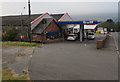
Northern entrance to a Gulf and Londis, Blaenavon
From the B4246 Abergavenny Road to a Gulf filling station and a small Londis shop.
Image: © Jaggery
Taken: 2 Oct 2015
0.01 miles
2
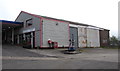
J T Jones, Blaenavon
Antiques & secondhand furniture salesroom in part of the Gulf service station building alongside the B4246.
Image: © Jaggery
Taken: 2 Oct 2015
0.01 miles
3
Wires over Abergavenny Road, Blaenavon
Low-flying birds beware!
Image: © Jaggery
Taken: 2 Oct 2015
0.02 miles
4
Direction sign, Blaenavon
Alongside the B4246. Stay on the B4246 for Abergavenny (vehicle weight limit 7.5 tonnes) or turn left on to the B4248 for Brynmawr.
Image: © Jaggery
Taken: 2 Oct 2015
0.02 miles
5
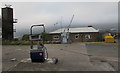
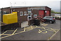
North side of Blaenavon Fire Station
Fire Station tower on the left, Fire Station in the middle, Firefighters' Charity donations bin http://www.geograph.org.uk/photo/4689574 on the right. The Gulf diesel pump is part of the filling station site http://www.geograph.org.uk/photo/4686396 behind the camera.
Image: © Jaggery
Taken: 2 Oct 2015
0.02 miles
6
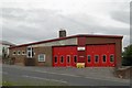
Blaenavon Fire Station
Blaenavon Fire Station, Cae White, Blaenavon is part of South Wales Fire & Rescue Service
Image: © Kevin Hale
Taken: 3 Jun 2007
0.02 miles
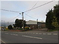
7
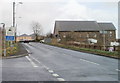
Two miles of steep gradient ahead, Abergavenny Road, Blaenavon
A sign on the side of the B4246 informs of 11% (1 in 9) uphill gradients for two miles ahead. Viewed from the corner of Garn Road. http://www.geograph.org.uk/photo/2371177
The building on the right looks like it may once have been a church. Its current usage is premises for a business designing, making and restoring wooden furniture and also providing antiques restoration and sales.
Image: © Jaggery
Taken: 3 Apr 2011
0.02 miles
8
Blaenavon Fire Station tower
In the NE corner of the Fire Station http://www.geograph.org.uk/photo/2369728 site on the east side of the B4246 Abergavenny Road.
The odd-looking machine is at the edge of a Gulf filling station.
Image: © Jaggery
Taken: 2 Oct 2015
0.02 miles
9
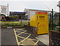
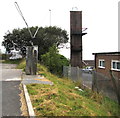
Yellow donations bin outside Blaenavon Fire Station
The Firefighters Charity bin is for donations of adults' and children's clothing (including underwear), linen, handbags and paired shoes. No toys, books, bric-a-brac or electrical goods. All proceeds from the sale of donated items stay in the UK helping injured firefighters.
Image: © Jaggery
Taken: 2 Oct 2015
0.03 miles
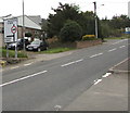
10
Yellow area outside Blaenavon Fire Station
A yellow donations bin http://www.geograph.org.uk/photo/4689574 is alongside the yellow parking area reserved for Blue Badge holders.
Image: © Jaggery
Taken: 2 Oct 2015
0.03 miles