IMAGES TAKEN NEAR TO
Castle Street, PONTYPOOL, NP4 9QL
Introduction
This page details the photographs taken nearby to Castle Street, NP4 9QL by members of the Geograph project.
The Geograph project started in 2005 with the aim of publishing, organising and preserving representative images for every square kilometre of Great Britain, Ireland and the Isle of Man.

There are currently over 7.5m images from over14,400 individuals and you can help contribute to the project by visiting https://www.geograph.org.uk
Image Map
Images are licensed for reuse under creativecommons.org/licenses/by-sa/2.0
Notes
- Clicking on the map will re-center to the selected point.
- The higher the marker number, the further away the image location is from the centre of the postcode.
Image Listing (603 Images Found)
Images are licensed for reuse under creativecommons.org/licenses/by-sa/2.0
Image
Details
Distance
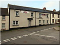
1
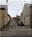
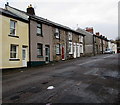
Castle Street, Blaenavon
Viewed across Phillips Street. Castle Street is a dead end for motor vehicles.
Walkers can use a path (past the fire station) to Abergavenny Road.
The fire station tower is in the background on the right.
Image: © Jaggery
Taken: 2 Oct 2015
0.02 miles
2
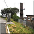
Blaenavon Fire Station tower
In the NE corner of the Fire Station http://www.geograph.org.uk/photo/2369728 site on the east side of the B4246 Abergavenny Road.
The odd-looking machine is at the edge of a Gulf filling station.
Image: © Jaggery
Taken: 2 Oct 2015
0.04 miles
3
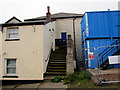
Steps up to a King Street house, Blaenavon
Formerly at the edge of a green area of trees and bushes, in early October 2015 the house is at the edge of a building site. http://www.geograph.org.uk/photo/4686286
Image: © Jaggery
Taken: 2 Oct 2015
0.04 miles
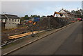
4
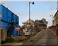
King Street building site, Blaenavon
Viewed in early October 2015. A nearby notice shows that this is a development of ten new homes at affordable rent for Melin housing association.
Image: © Jaggery
Taken: 2 Oct 2015
0.04 miles
5
West side of Phillips Street, Blaenavon
The gap in the houses is at the Castle Street junction. http://www.geograph.org.uk/photo/4682832
Image: © Jaggery
Taken: 22 Nov 2016
0.04 miles
6
Phillips Street houses north of Castle Street, Blaenavon
The Castle Street http://www.geograph.org.uk/photo/4682832 junction is on the left.
Image: © Jaggery
Taken: 22 Nov 2016
0.04 miles
7
Alma Street, Blaenavon
Houses on the NE side of the street, viewed from the corner of Ellick Street.
Image: © Jaggery
Taken: 25 Oct 2010
0.05 miles
8
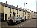
King Street, Blaenavon
Looking west past the corner of Bethel Lane. The Fountain (Fountain Inn) http://www.geograph.org.uk/photo/4682812 is in the background.
Image: © Jaggery
Taken: 2 Oct 2015
0.05 miles
9
The Fountain (Fountain Inn) Blaenavon
King Street pub opposite Phillips Street.
Image: © Jaggery
Taken: 2 Oct 2015
0.05 miles
10
Fenced-off south side of King Street, Blaenavon
Work in progress in early October 2015 on the construction of ten new homes at affordable rent for Melin housing association.
Image: © Jaggery
Taken: 2 Oct 2015
0.05 miles