IMAGES TAKEN NEAR TO
Capel Newydd Avenue, PONTYPOOL, NP4 9LG
Introduction
This page details the photographs taken nearby to Capel Newydd Avenue, NP4 9LG by members of the Geograph project.
The Geograph project started in 2005 with the aim of publishing, organising and preserving representative images for every square kilometre of Great Britain, Ireland and the Isle of Man.

There are currently over 7.5m images from over14,400 individuals and you can help contribute to the project by visiting https://www.geograph.org.uk
Image Map
Images are licensed for reuse under creativecommons.org/licenses/by-sa/2.0
Notes
- Clicking on the map will re-center to the selected point.
- The higher the marker number, the further away the image location is from the centre of the postcode.
Image Listing (70 Images Found)
Images are licensed for reuse under creativecommons.org/licenses/by-sa/2.0
Image
Details
Distance
1
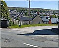
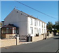
Hillside view, Blaenavon
Viewed across the B4246 Varteg Road and Rowan Way in May 2023.
Image: © Jaggery
Taken: 20 May 2023
0.04 miles
2
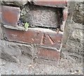
Ordnance Survey Cut Mark
This damaged OS cut mark can be found on the wall of Glenside, NE side of Blaenavon Road. It marks a point 312.877m above mean sea level.
Image: © Adrian Dust
Taken: 18 Aug 2018
0.04 miles
3
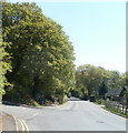
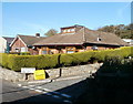
Bus stop dwarfed by trees, Cwmavon Road, Blaenavon
The bus stop is on the corner of Capel Newydd Avenue.
Image: © Jaggery
Taken: 28 Apr 2011
0.07 miles
4
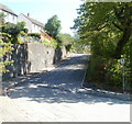
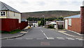
Capel Newydd Avenue, Blaenavon
Capel Newydd Avenue climbs away from Cwmavon Road.
Image: © Jaggery
Taken: 28 Apr 2011
0.08 miles
5
Llanover Road houses, Blaenavon
Houses on the north side of Llanover Road, a few metres west of the junction with Brights Lane.
Image: © Jaggery
Taken: 25 Oct 2010
0.12 miles
6
Corner of Llanover Road and Brights Lane, Blaenavon
Viewed across Llanover Road.
Image: © Jaggery
Taken: 25 Oct 2010
0.13 miles
7
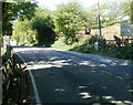
40mph speed on Cwmavon Road on leaving Blaenavon
Heading SE, Cwmavon Road leaves Blaenavon and its 30mph speed limit.
Image: © Jaggery
Taken: 28 Apr 2011
0.13 miles
8
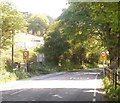
SE boundary of Blaenavon
Cwmavon Road reaches the Blaenavon boundary sign, a reduction in the speed limit from 40mph to 30mph, and an inquisitive horse! The sign shows that Blaenavon is twinned with Coutras, SW France.
Most of Blaenavon is at an elevation at least 1,000 feet above mean sea level.
This boundary, one of the lower parts of Blaenavon, is 1,010 feet (308 metres) above sea level.
Image: © Jaggery
Taken: 28 Apr 2011
0.13 miles
9
Down Coed Road, Blaenavon
Coed Road descends from Llanover Road towards the A4043 Cwmavon Road nearly 300 metres ahead.
Image: © Jaggery
Taken: 23 Sep 2015
0.14 miles
10
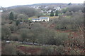
Cae-Dalwyn Farm
Farm viewed across the valley from the Avon Lwyd Trail. The A4043 is at the bottom of the picture.
Image: © M J Roscoe
Taken: 6 Jan 2023
0.15 miles