IMAGES TAKEN NEAR TO
Tymynydd Close, PONTYPOOL, NP4 9JH
Introduction
This page details the photographs taken nearby to Tymynydd Close, NP4 9JH by members of the Geograph project.
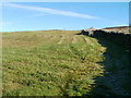
The Geograph project started in 2005 with the aim of publishing, organising and preserving representative images for every square kilometre of Great Britain, Ireland and the Isle of Man.

There are currently over 7.5m images from over14,400 individuals and you can help contribute to the project by visiting https://www.geograph.org.uk
Image Map
Images are licensed for reuse under creativecommons.org/licenses/by-sa/2.0
Notes
- Clicking on the map will re-center to the selected point.
- The higher the marker number, the further away the image location is from the centre of the postcode.
Image Listing (123 Images Found)
Images are licensed for reuse under creativecommons.org/licenses/by-sa/2.0
Image
Details
Distance
1
Path from Middle Coedcae to Upper Coedcae, Blaenavon
Past the edge of the Recreation Ground, the home ground of Blaenavon RFC (rugby club).
Image: © Jaggery
Taken: 23 Sep 2015
0.03 miles
2
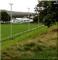
Recreation Ground floodlights, Blaenavon
The Recreation Ground in Blaenavon Park is the home ground of Blaenavon RFC (rugby club).
Image: © Jaggery
Taken: 23 Sep 2015
0.05 miles
3
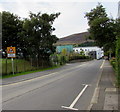
Arthur Jenkins Care Home, Blaenavon
Set back from the east side of the road named Middle Coedcae.
Image: © Jaggery
Taken: 23 Sep 2015
0.07 miles
4
Looking west from high ground, Upper Coedcae
The view west from ground at about 430 metres (1410 feet) above sea level.
The view
north http://www.geograph.org.uk/photo/2134745
south http://www.geograph.org.uk/photo/2134761
east http://www.geograph.org.uk/photo/2134768
from the same spot.
Image: © Jaggery
Taken: 25 Oct 2010
0.09 miles
5
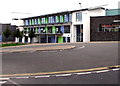
Blaenavon Heritage Voluntary Controlled Primary School, Middle Coedcae, Blaenavon
The school was built in the 21st century, c2010.
Image: © Jaggery
Taken: 23 Sep 2015
0.09 miles
6
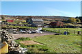
Moorland farm buildings, Blaenavon
The buildings are on hillside on the NE side of Upper Coedcae Road, at about 1250 feet (roughly 380 metres) above sea level.
Image: © Jaggery
Taken: 25 Oct 2010
0.09 miles
7
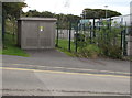
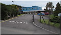
Blaenavon School electricity substation, Blaenavon
Viewed across Middle Coedcae. Located near the NW corner of Blaenavon Heritage VC Primary School,
the Western Power Distribution electricity substation identifier is BLAENAVON SCHOOL S/S No. 53-7138
Image: © Jaggery
Taken: 23 Sep 2015
0.10 miles
8
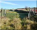
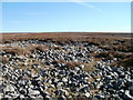
Visitors not welcome in moorland field, Blaenavon
A generous helping of barbed wire tops a padlocked gate at the entrance to a moorland field at the end of a path from Upper Coedcae Road, at the NE edge of Blaenavon.
Image: © Jaggery
Taken: 25 Oct 2010
0.10 miles
9
Moorland field, NE Blaenavon
Viewed from the public side of a padlocked gate topped with barbed wire. http://www.geograph.org.uk/photo/2134462
Despite bright sunshine, a pocket of hoar frost remains in the lower right corner, in the shade of a stone wall, at 11.30 on a late October morning. The land nearest the camera is about 1250 feet (380 metres) above sea level.
Image: © Jaggery
Taken: 25 Oct 2010
0.10 miles
10
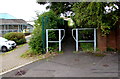
Warning sign - Patrol/Hebryngwr, Middle Coedcae, Blaenavon
The English/Welsh sign faces Middle Coedcae on the descent towards school entrance gates. http://www.geograph.org.uk/photo/5597480
Image: © Jaggery
Taken: 23 Sep 2015
0.10 miles