IMAGES TAKEN NEAR TO
Llanover Road, PONTYPOOL, NP4 9HX
Introduction
This page details the photographs taken nearby to Llanover Road, NP4 9HX by members of the Geograph project.
The Geograph project started in 2005 with the aim of publishing, organising and preserving representative images for every square kilometre of Great Britain, Ireland and the Isle of Man.

There are currently over 7.5m images from over14,400 individuals and you can help contribute to the project by visiting https://www.geograph.org.uk
Image Map
Images are licensed for reuse under creativecommons.org/licenses/by-sa/2.0
Notes
- Clicking on the map will re-center to the selected point.
- The higher the marker number, the further away the image location is from the centre of the postcode.
Image Listing (21 Images Found)
Images are licensed for reuse under creativecommons.org/licenses/by-sa/2.0
Image
Details
Distance
1
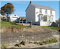
House near the edge of Blaenavon Community Woodland
House at the eastern end both of Llanover Road and of residential Blaenavon. A few metres away is the entrance to Blaenavon Community Woodland. http://www.geograph.org.uk/photo/2135404
Image: © Jaggery
Taken: 25 Oct 2010
0.05 miles
2
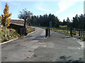
Cattle grid at entrance to Blaenavon Community Woodland
At the eastern end of residential Blaenavon, Llanover Road approaches a cattle grid at the entrance to Blaenavon Community Woodland. That's not a dumped tyre on the edge of the cattle grid. It is chained in place (and there is another tyre on the other side of the grid) to prevent vehicles contacting the railings.
Image: © Jaggery
Taken: 25 Oct 2010
0.05 miles
3
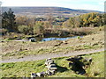
Pond near entrance to Blaenavon Community Woodland
The pond is a few metres from the cattle grid http://www.geograph.org.uk/photo/2135404 at the entrance to the woodland.
Image: © Jaggery
Taken: 25 Oct 2010
0.05 miles
4
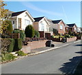
Llanover Road houses, Blaenavon
Houses on the north side of Llanover Road.
Image: © Jaggery
Taken: 25 Oct 2010
0.07 miles
5
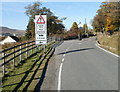
Signs at western exit from Blaenavon Community Woodland
Beneath a sign warning of a cattle grid (more accurately in this area, sheep grid) is a symbol of a horse and wagon and an arrow pointing to a side gate alongside the cattle grid. Presumably the ' & animals' is directed at any animal smart enough to read...
Image: © Jaggery
Taken: 25 Oct 2010
0.08 miles
6
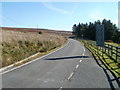
Western edge of Blaenavon Community Woodland
Woodland on the fenced off right side of the road, unfenced treeless moorland on the left side. The main factor in the presence or absence of trees in this part of SE Wales is not altitude, but grazing sheep, which prevent trees becoming established. The sheep have the moorland, the trees have the fenced-off areas.
Image: © Jaggery
Taken: 25 Oct 2010
0.13 miles
7
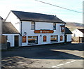
The Pottery, Blaenavon
Pub on Llanover Road, viewed from Giles Road. Attractions advertised on boards on the wall include bar food; real ales; beer garden; pool&darts; big screen TV.
Image: © Jaggery
Taken: 25 Oct 2010
0.15 miles
8
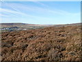
Looking south from high ground, Upper Coedcae
The view south from ground at about 430 metres (1410 feet) above sea level.
The view
north http://www.geograph.org.uk/photo/2134745
west http://www.geograph.org.uk/photo/2134755
east http://www.geograph.org.uk/photo/2134768
from the same spot.
Image: © Jaggery
Taken: 25 Oct 2010
0.15 miles
9
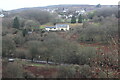
Cae-Dalwyn Farm
Farm viewed across the valley from the Avon Lwyd Trail. The A4043 is at the bottom of the picture.
Image: © M J Roscoe
Taken: 6 Jan 2023
0.18 miles
10
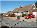
Llanover Road Estate, Blaenavon
Bungalows on Llanover Road Estate, a small area of housing along two parallel roads on the west side of Giles Road.
Image: © Jaggery
Taken: 25 Oct 2010
0.19 miles