IMAGES TAKEN NEAR TO
Bryn Terrace, PONTYPOOL, NP4 9HF
Introduction
This page details the photographs taken nearby to Bryn Terrace, NP4 9HF by members of the Geograph project.
The Geograph project started in 2005 with the aim of publishing, organising and preserving representative images for every square kilometre of Great Britain, Ireland and the Isle of Man.

There are currently over 7.5m images from over14,400 individuals and you can help contribute to the project by visiting https://www.geograph.org.uk
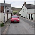
Image Map
Images are licensed for reuse under creativecommons.org/licenses/by-sa/2.0
Notes
- Clicking on the map will re-center to the selected point.
- The higher the marker number, the further away the image location is from the centre of the postcode.
Image Listing (561 Images Found)
Images are licensed for reuse under creativecommons.org/licenses/by-sa/2.0
Image
Details
Distance
1
RSPCA Animal Found notice on a Blaenavon lamppost
On September 23rd 2015, this Upper Hill Street lamppost is displaying a notice which states that a snake found nearby on September 16th is now in the care of the RSPCA.
The notice gives a phone number to ring if this could be your animal which is now missing.
Image: © Jaggery
Taken: 23 Sep 2015
0.02 miles
2
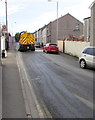
Street cleaning, Upper Hill Street, Blaenavon
Road surface mud from the tyres of lorries leaving a nearby building site needs to be cleaned up.
Image: © Jaggery
Taken: 23 Sep 2015
0.02 miles
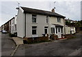
3
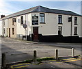
Cambrian Inn, Blaenavon
The pub on the corner of Lower Hill Street and Llanover Road dates from the mid 19th century.
Image: © Jaggery
Taken: 23 Sep 2015
0.02 miles
4
Obsolete Patrol sign, Upper Hill Street, Blaenavon
The red-edge triangular sign remains in place in September 2015.
The adjacent former school site is now a house construction site.
Image: © Jaggery
Taken: 23 Sep 2015
0.03 miles
5
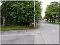
Brookside leading to Sunnybank, Blaenavon
On the north side of Llanover Road.
Image: © Jaggery
Taken: 23 Sep 2015
0.03 miles
6
Llanover Road, Blaenavon
Viewed across Middle Coedcae looking towards the Charles Street junction. http://www.geograph.org.uk/photo/4671489
Image: © Jaggery
Taken: 23 Sep 2015
0.03 miles
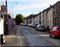
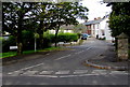
7
Queen Street, Blaenavon
Confusingly, three maps give this street three different names - the western end of Llanover Road, Bryn Terrace or Queen Street. I've used the latter, the one shown on a large-scale Ordnance Survey map. What is certain is that St Paul's Church http://www.geograph.org.uk/photo/2135913 is at the right edge of the photo.
Image: © Jaggery
Taken: 25 Oct 2010
0.03 miles
8
Water marker post, Llanover Road, Blaenavon
The post is alongside the perimeter fence on the west side of St Paul's Church.
Image: © Jaggery
Taken: 23 Sep 2015
0.04 miles
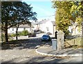
9
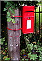
Red postbox on a green corner of Blaenavon
Opposite Brookside, http://www.geograph.org.uk/photo/4671482 the Royal Mail postbox http://www.geograph.org.uk/photo/4672551 is fixed to a wooden post at the edge of Llanover Road.
Image: © Jaggery
Taken: 23 Sep 2015
0.04 miles
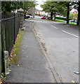
10
Queen Elizabeth II postbox on a pole in Blaenavon
Recently painted in late September 2015, the Royal Mail postbox is here. http://www.geograph.org.uk/photo/4672548
Image: © Jaggery
Taken: 23 Sep 2015
0.04 miles