IMAGES TAKEN NEAR TO
Cwmavon Road, PONTYPOOL, NP4 9DZ
Introduction
This page details the photographs taken nearby to Cwmavon Road, NP4 9DZ by members of the Geograph project.
The Geograph project started in 2005 with the aim of publishing, organising and preserving representative images for every square kilometre of Great Britain, Ireland and the Isle of Man.

There are currently over 7.5m images from over14,400 individuals and you can help contribute to the project by visiting https://www.geograph.org.uk
Image Map
Images are licensed for reuse under creativecommons.org/licenses/by-sa/2.0
Notes
- Clicking on the map will re-center to the selected point.
- The higher the marker number, the further away the image location is from the centre of the postcode.
Image Listing (20 Images Found)
Images are licensed for reuse under creativecommons.org/licenses/by-sa/2.0
Image
Details
Distance
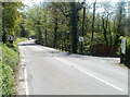
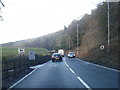
1
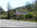
Halfway House between Blaenavon and Cwmavon
Viewed from Cwmavon Road (A4043) on the east bank of the Afon Lwyd.
The house is on the west bank of the river, NE of Ty Michael Farm.
Image: © Jaggery
Taken: 28 Apr 2011
0.07 miles
2
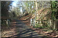
Footpath crossing the Afon Lwyd Trail, NCR 492
The former LNWR trackbed and its verges are part of the linear Cwmavon Local Nature Reserve.
Image: © M J Roscoe
Taken: 25 Feb 2022
0.09 miles
3
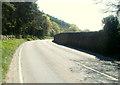
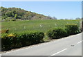
Cwmavon Road passes the edge of Cwmavon Reservoir
A high stone wall prevents access from here to the reservoir, which was built in the late 19th century by the Pontypool Gas & Water Co. The reservoir, still in use, is about 120 metres long, and 65 metres wide at its widest point.
Image: © Jaggery
Taken: 28 Apr 2011
0.10 miles
4
Looking towards the Afon Lwyd valley from the B4246 north of Varteg
The wooded lowlands of the Afon Lwyd valley contrast with moorland on higher ground. Viewed from Varteg Road (B4246).
Image: © Jaggery
Taken: 17 Jul 2011
0.11 miles
5
Southern edge of Cwmavon Reservoir
Viewed from Cwmavon Road (A4043) at the southern end of the reservoir perimeter wall. http://www.geograph.org.uk/photo/2921440
The mound is at the southern edge of the reservoir, which was built in the late 19th century by the Pontypool Gas & Water Co. The reservoir, still in use, is about 120 metres long, and 65 metres wide
at its widest point.
Image: © Jaggery
Taken: 28 Apr 2011
0.12 miles
6
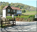
Reservoir House near Cwmavon
Located at the southern edge of Cwmavon Reservoir, Reservoir House is the premises of Keepers Cottage Centre (cattery and dog boarding kennels). Viewed from Cwmavon Road (A4043).
Image: © Jaggery
Taken: 28 Apr 2011
0.12 miles
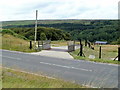
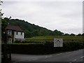
7
Turn right here for the cattery and kennels north of Cwmavon
Signs alongside Cwmavon Road (A4043) indicate the entrance to Keepers Cottage Centre. http://www.geograph.org.uk/photo/2921463
Image: © Jaggery
Taken: 28 Apr 2011
0.12 miles
8
Keeper's Cottage stands next to the reservoir mound
Image: © Carol Rose
Taken: 16 Jun 2007
0.13 miles
10
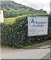
Keepers Cottage nameboard, Torfaen
Text on the board facing the A4043 Cwmavon Road in June 2024 includes
"Boarding Kennels & Cattery
Opening Times
8.30am - 5pm 7 Days a week".
Image: © Jaggery
Taken: 23 Jun 2024
0.15 miles