IMAGES TAKEN NEAR TO
Varteg Road, PONTYPOOL, NP4 9DY
Introduction
This page details the photographs taken nearby to Varteg Road, NP4 9DY by members of the Geograph project.
The Geograph project started in 2005 with the aim of publishing, organising and preserving representative images for every square kilometre of Great Britain, Ireland and the Isle of Man.

There are currently over 7.5m images from over14,400 individuals and you can help contribute to the project by visiting https://www.geograph.org.uk
Image Map
Images are licensed for reuse under creativecommons.org/licenses/by-sa/2.0
Notes
- Clicking on the map will re-center to the selected point.
- The higher the marker number, the further away the image location is from the centre of the postcode.
Image Listing (96 Images Found)
Images are licensed for reuse under creativecommons.org/licenses/by-sa/2.0
Image
Details
Distance
1
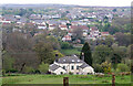
Coed Avon from Blaenavon's Heritage Railway
This large house gives its name to the end of the heritage railway line. It is not possible to board or alight here as there are no platforms.
Image: © Chris Allen
Taken: 2 May 2022
0.00 miles
2
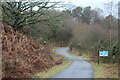
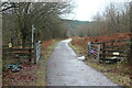
Cycle path on dismantled railway
NCR 492 veers to the left as it approaches the end of the heritage railway line which is a short distance behind the information board. The board marks the northern end of the linear Cwmavon local nature reserve.
Image: © M J Roscoe
Taken: 6 Jan 2023
0.08 miles
3
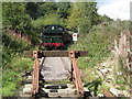
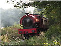
Pontypool & Blaenavon Railway
The new southern end of the line was brought into use during the railway's steam gala. Ex-Great Western pannier tank No. 6435 is seen at the bufferstops at Coed-avon.
Image: © Gareth James
Taken: 12 Sep 2015
0.08 miles
4
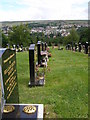
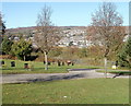
Looking past the well tended graves to Blaenavon
Image: © Carol Rose
Taken: 15 Jun 2007
0.11 miles
5
Pontypool & Blaenavon Railway
Austerity 0-6-0T No. 71515 is seen during the railway's steam gala heading away from Coed-avon, on the southern extension from Blaenavon High Level on just brought back into use.
Image: © Gareth James
Taken: 12 Sep 2015
0.12 miles
6
Footpath crossing the Avon Lwyd Trail
The trail, NCR 492, here is on a former LNWR track bed, part of the linear Cwmavon local nature reserve.
Image: © M J Roscoe
Taken: 6 Jan 2023
0.13 miles
7
Silver birches, Varteg Road cemetery, Blaenavon
Two trees alongside the loop at the northern edge of the road through the easternmost section of the cemetery. In the background is the eastern part of Blaenavon.
Image: © Jaggery
Taken: 25 Oct 2010
0.15 miles
8
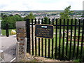
Varteg Road Cemetery
This huge cemetery reflects the fact that Blaenavon was once twice its current size during the Industrial Revolution.
Image: © Carol Rose
Taken: 15 Jun 2007
0.16 miles
9
Road in Blaenavon Cemetery
Also known as Varteg Hill Cemetery, accessed from the B4246 Varteg Road behind the camera.
Image: © Jaggery
Taken: 20 May 2023
0.16 miles
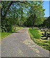
10
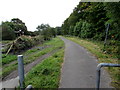
Combined footpath and cycleway, Blaenavon
Part of National Cycle Network route 492, southeast of this http://www.geograph.org.uk/photo/4677109 barrier.
Image: © Jaggery
Taken: 20 Sep 2015
0.16 miles