IMAGES TAKEN NEAR TO
Clapham Terrace, PONTYPOOL, NP4 9DE
Introduction
This page details the photographs taken nearby to Clapham Terrace, NP4 9DE by members of the Geograph project.
The Geograph project started in 2005 with the aim of publishing, organising and preserving representative images for every square kilometre of Great Britain, Ireland and the Isle of Man.

There are currently over 7.5m images from over14,400 individuals and you can help contribute to the project by visiting https://www.geograph.org.uk
Image Map
Images are licensed for reuse under creativecommons.org/licenses/by-sa/2.0
Notes
- Clicking on the map will re-center to the selected point.
- The higher the marker number, the further away the image location is from the centre of the postcode.
Image Listing (90 Images Found)
Images are licensed for reuse under creativecommons.org/licenses/by-sa/2.0
Image
Details
Distance
1
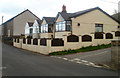
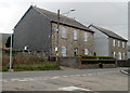
Forge Road bungalows, Forgeside
The two semi-detached bungalows are on the corner of Forge Road and Clapham Terrace. http://www.geograph.org.uk/photo/2849804
Image: © Jaggery
Taken: 15 Apr 2011
0.02 miles
2
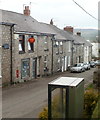
Forgeside Post Office and shop, Blaenavon
The post office and shop are at 8 Clapham Terrace, Forgeside.
Image: © Jaggery
Taken: 15 Apr 2011
0.02 miles
3
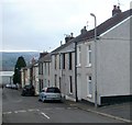
Looking down Oxford Terrace, Forgeside, Blaenavon
Viewed from the corner of Coity Terrace looking towards Forge Road
along houses on the west side of Oxford Terrace.
Image: © Jaggery
Taken: 15 Apr 2011
0.02 miles
4
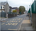
Forge Road bus stop, Forgeside, Blaenavon
A view west along Forge Road. The large building next to a tree is the derelict former school http://www.geograph.org.uk/photo/2850050 on the corner of Oxford Terrace. The wall and green fence on the right are at the perimeter of an industrial area extending for about 600 metres along the north side of the residential part of Forgeside.
Image: © Jaggery
Taken: 15 Apr 2011
0.02 miles
5

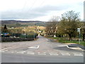
Corner of Forgeside Road and Forge Road, Forgeside
Forgeside Road, which connects with Varteg Road about 800 metres behind the camera, bends to the right here. The road on the left, which heads into the central area of Forgeside village, is Forge Road.
In view is the eastern edge of a factory.
Image: © Jaggery
Taken: 15 Apr 2011
0.05 miles
6
Forgeside Road heads away from Forge Road, Forgeside
Forgeside Road heads NNE away from the eastern edge of the village of Forgeside.
Image: © Jaggery
Taken: 15 Apr 2011
0.05 miles
7
Detached houses, Forge Road, Forgeside
The house on the right was formerly the Forgeside Inn.
Image: © Jaggery
Taken: 15 Apr 2011
0.05 miles
8
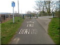
End of cycle route, Forgeside Road, Forgeside
The connecting cycleway from National Cycle Network route 46 to Forgeside Road ends at the edge of the road. Sturdy metal barriers and a locked metal gate prevent inappropriate vehicles entering the cycleway from Forgeside Road.
Image: © Jaggery
Taken: 15 Apr 2011
0.05 miles
9
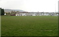
Clapham Terrace viewed across a rugby pitch, Forgeside
Image: © Jaggery
Taken: 15 Apr 2011
0.05 miles
10
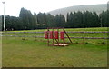
Rugby scrum training equipment, Forgeside
The equipment is at the edge of a rugby pitch on the east side of Clapham Terrace.
Image: © Jaggery
Taken: 15 Apr 2011
0.07 miles