IMAGES TAKEN NEAR TO
Brutes Row, PONTYPOOL, NP4 9BP
Introduction
This page details the photographs taken nearby to Brutes Row, NP4 9BP by members of the Geograph project.
The Geograph project started in 2005 with the aim of publishing, organising and preserving representative images for every square kilometre of Great Britain, Ireland and the Isle of Man.

There are currently over 7.5m images from over14,400 individuals and you can help contribute to the project by visiting https://www.geograph.org.uk
Image Map
Images are licensed for reuse under creativecommons.org/licenses/by-sa/2.0
Notes
- Clicking on the map will re-center to the selected point.
- The higher the marker number, the further away the image location is from the centre of the postcode.
Image Listing (233 Images Found)
Images are licensed for reuse under creativecommons.org/licenses/by-sa/2.0
Image
Details
Distance
1
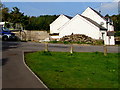
White house near Forgeside
Viewed from the path west from Aaron Brute's Bridge http://www.geograph.org.uk/photo/4766160 over the Afon Lwyd.
Image: © Jaggery
Taken: 19 Sep 2015
0.02 miles
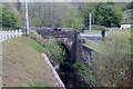
2
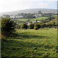
South towards Forgeside
Viewed from near these http://www.geograph.org.uk/photo/4674612 field gates.
Image: © Jaggery
Taken: 19 Sep 2015
0.03 miles
3
Information board for Aaron Brute's Level and Iron Bridge near Forgeside
The board is located between the stone bridge on the left and the early 19th century
iron bridge (Aaron Brute's Bridge) http://www.geograph.org.uk/photo/4766160 a few metres out of shot on the right.
Aaron Brute's Level is a partially buried coal and ironstone level
entry built by Aaron Brute between 1812 and 1818, disused by 1843.
Image: © Jaggery
Taken: 19 Sep 2015
0.04 miles
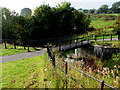
4
Road bridge over the Afon Lwyd near Forgeside
The stone bridge crosses the Afon Lwyd 35 metres upstream
from Aaron Brute's Bridge, an early 19th century iron bridge. http://www.geograph.org.uk/photo/4766160
Image: © Jaggery
Taken: 19 Sep 2015
0.04 miles
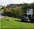
6
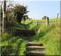
Steps and path to Forgeside Road, Forgeside
This steep, direct route extends for 75 metres to Forgeside Road.
Walkers have the alternative of a 170 metre long road route,
where there are no pavements. I chose this vehicle-free direct route.
Image: © Jaggery
Taken: 19 Sep 2015
0.04 miles
7
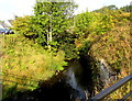
Infant Afon Lwyd upstream from Aaron Brute's Bridge
Viewed from this http://www.geograph.org.uk/photo/4766160 early 19th century bridge. The river is here less than 500 metres from its source.
Image: © Jaggery
Taken: 19 Sep 2015
0.05 miles
8
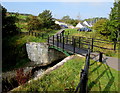
Aaron Brute's Bridge - Gateway to Forgeside
A nearby information board states that at peak production, the ironworks at Blaenavon needed a constant supply of coal. In 1812, a new mine was sunk into the hillside nearby, on the other side of the river (the Afon Lwyd). A bridge was needed to provide a more direct route from mine to ironworks.
The bridge seen here is the one that was built to give that route. It is one of the oldest remaining iron bridges in Wales. It bears the name of Aaron Brute, a Monmouthshire stonemason who may have been the manager of the mine at that time.
The bridge supported an early form of railway, a horse-drawn tramroad, along which coal was transported. It seems that the mine was not very productive, and closed down after little more than 20 years. The bridge remained, eventually becoming a footbridge linking the community of Forgeside on one side of the river valley with the town of Blaenavon on the other side.
After years of neglect, Aaron Brute's Bridge was recently restored as a footbridge, and a reminder of the ingenuity and endeavour that forged what is now a world heritage landscape
Image: © Jaggery
Taken: 19 Sep 2015
0.05 miles
9
Aaron Brute's Bridge over the Afon Lwyd
See http://www.geograph.org.uk/photo/4766160 for another view and some details.
Image: © Jaggery
Taken: 19 Sep 2015
0.05 miles
10
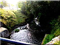
Afon Lwyd downstream from Aaron Brute's Bridge
Viewed from this http://www.geograph.org.uk/photo/4766160 early 19th century iron bridge.
Image: © Jaggery
Taken: 19 Sep 2015
0.05 miles