IMAGES TAKEN NEAR TO
Avon Road, PONTYPOOL, NP4 9AT
Introduction
This page details the photographs taken nearby to Avon Road, NP4 9AT by members of the Geograph project.
The Geograph project started in 2005 with the aim of publishing, organising and preserving representative images for every square kilometre of Great Britain, Ireland and the Isle of Man.

There are currently over 7.5m images from over14,400 individuals and you can help contribute to the project by visiting https://www.geograph.org.uk
Image Map
Images are licensed for reuse under creativecommons.org/licenses/by-sa/2.0
Notes
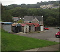
- Clicking on the map will re-center to the selected point.
- The higher the marker number, the further away the image location is from the centre of the postcode.
Image Listing (479 Images Found)
Images are licensed for reuse under creativecommons.org/licenses/by-sa/2.0
Image
Details
Distance
1
Lockup garages, Brynavon, Blaenavon
Viewed from these https://www.geograph.org.uk/photo/6597942 steps.
Image: © Jaggery
Taken: 9 Sep 2020
0.01 miles
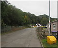
2
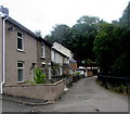
East along Avon Road, Blaenavon
Viewed from the corner of Brynavon. The houses are opposite a river,
the Afon Lwyd, here about 300 metres (c985 ft) above mean sea level.
Image: © Jaggery
Taken: 9 Sep 2020
0.02 miles
3
Steps down to Brynavon, Blaenavon
Steps descend from Cwmavon Road towards houses in Brynavon.
Image: © Jaggery
Taken: 28 Apr 2011
0.02 miles
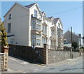
4
Brynavon, Blaenavon
Housing opposite lockup garages. https://www.geograph.org.uk/photo/6598190 The sign on the wall on the left shows BRYNAVON 16-13
Image: © Jaggery
Taken: 9 Sep 2020
0.02 miles
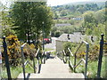
5
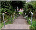
Steps down from Cwmavon Road, Blaenavon
Long flight of steps descending from the south side of Cwmavon Road towards Brynavon and Avon Road.
Image: © Jaggery
Taken: 9 Sep 2020
0.03 miles
6
West along Avon Road, Blaenavon
Viewed from the corner of Brynavon. The trees and bushes are on a bank of
a river, the Afon Lwyd, here about 300 metres (c985 ft) above mean sea level.
Image: © Jaggery
Taken: 9 Sep 2020
0.04 miles
7
Cwmavon Road houses, Blaenavon
The left turn between the houses is into Ton Mawr Avenue. http://www.geograph.org.uk/photo/2852379
Image: © Jaggery
Taken: 28 Apr 2011
0.04 miles
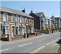
8
Corner semis, Cwmavon Road, Blaenavon
The two semi-detached houses on the corner of Greenfield Place
are conspicuously larger than neighbouring Cwmavon Road houses.
Image: © Jaggery
Taken: 28 Apr 2011
0.04 miles
9
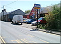
Cwmavon Road garage, Blaenavon
Business providing an MoT test centre, and selling second-hand cars, tyres, exhausts etc.
Image: © Jaggery
Taken: 28 Apr 2011
0.04 miles
10
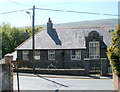
Former school, Cwmavon Road, Blaenavon
The word BOYS inscribed in stone above a doorway of this building opposite Greenfield Place http://www.geograph.org.uk/photo/2852383 is a reminder of its former use as a school. The building was later used for a while as an Outdoor Pursuits Centre by Brittons School and Technology College, Rainham, Essex.
The current use, if any, of the building is unknown to this contributor.
Image: © Jaggery
Taken: 28 Apr 2011
0.04 miles