IMAGES TAKEN NEAR TO
Varteg, PONTYPOOL, NP4 8UG
Introduction
This page details the photographs taken nearby to NP4 8UG by members of the Geograph project.
The Geograph project started in 2005 with the aim of publishing, organising and preserving representative images for every square kilometre of Great Britain, Ireland and the Isle of Man.

There are currently over 7.5m images from over14,400 individuals and you can help contribute to the project by visiting https://www.geograph.org.uk
Image Map
Images are licensed for reuse under creativecommons.org/licenses/by-sa/2.0
Notes
- Clicking on the map will re-center to the selected point.
- The higher the marker number, the further away the image location is from the centre of the postcode.
Image Listing (73 Images Found)
Images are licensed for reuse under creativecommons.org/licenses/by-sa/2.0
Image
Details
Distance
1
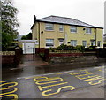
Varteg Road houses, Varteg
Semi-detached houses located near the corner of Salisbury Terrace.
Image: © Jaggery
Taken: 11 May 2017
0.00 miles
2
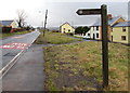
Cwm Ffrwd Heritage Trail direction sign, Varteg
The sign alongside the B4246 Varteg Road points towards Salisbury Terrace. https://www.geograph.org.uk/photo/6394821
Image: © Jaggery
Taken: 15 Mar 2018
0.01 miles
3
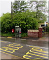
Varteg Road phonebox and postbox, Varteg
Alongside the B4246 Varteg Road near the corner of Salisbury Terrace.
Image: © Jaggery
Taken: 11 May 2017
0.01 miles
4
Queen Elizabeth II postbox and a BT box, Varteg Road, Varteg
Viewed across the B4246 Varteg Road in March 2018.
The former BT phonebox is now only a BT box - the phone has been removed. https://www.geograph.org.uk/photo/5711374
Image: © Jaggery
Taken: 15 Mar 2018
0.01 miles
5
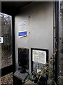
Inside a former BT phonebox, Varteg
Viewed in March 2018. The phone has been removed from this https://www.geograph.org.uk/photo/5711371 BT box.
Image: © Jaggery
Taken: 15 Mar 2018
0.01 miles
6
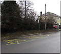
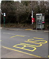
X24 bus stop, Varteg Road, Varteg
This stop on the west side of the B4246 Varteg Road is for buses on Stagecoach route X24 to Blaenavon.
Image: © Jaggery
Taken: 15 Mar 2018
0.02 miles
7
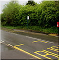
X24 bus stops near Salisbury Terrace, Varteg
Viewed from the bus stop with a shelter looking across the B4246 Varteg Road towards the shelterless bus stop for buses on Stagecoach route X24 to Blaenavon. The X24 stop on the camera side is for buses to Cardiff via Pontypool, Cwmbran and the Malpas area of Newport.
Image: © Jaggery
Taken: 11 May 2017
0.03 miles
8
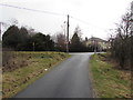
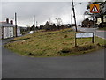
Minor road towards the B4246, Varteg
From Kears Row to the B4246 Varteg Road.
Image: © Jaggery
Taken: 15 Mar 2018
0.03 miles
9
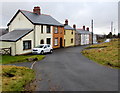
Kears Row/Rhes Kears in Varteg
Row of houses below the east side of the B4246 Varteg Road. Coflein records that Kears Row (Rhes Kears in Welsh) was originally a row of four early 19th century houses built for workmen associated with Varteg Ironworks. The first edition Ordnance Survey shows a brewery at the end of the row, probably now the yellow house - the two houses on the left appear to be later additions to the row.
Image: © Jaggery
Taken: 15 Mar 2018
0.03 miles
10
Kears Row/Rhes Kears name sign in Varteg
English/Welsh sign facing the B4246 Varteg Road near this https://www.geograph.org.uk/photo/6394809 row of houses.
Image: © Jaggery
Taken: 15 Mar 2018
0.03 miles