IMAGES TAKEN NEAR TO
Mamhilad, PONTYPOOL, NP4 8RD
Introduction
This page details the photographs taken nearby to NP4 8RD by members of the Geograph project.
The Geograph project started in 2005 with the aim of publishing, organising and preserving representative images for every square kilometre of Great Britain, Ireland and the Isle of Man.

There are currently over 7.5m images from over14,400 individuals and you can help contribute to the project by visiting https://www.geograph.org.uk
Image Map
Images are licensed for reuse under creativecommons.org/licenses/by-sa/2.0
Notes
- Clicking on the map will re-center to the selected point.
- The higher the marker number, the further away the image location is from the centre of the postcode.
Image Listing (12 Images Found)
Images are licensed for reuse under creativecommons.org/licenses/by-sa/2.0
Image
Details
Distance
1
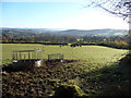
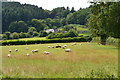
Field above Mamhilad
A rural scene overlooking the Mamhilad area.
Image: © Jeremy Bolwell
Taken: 18 Nov 2012
0.04 miles
2
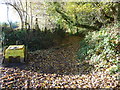
Part of the 'Roman Road' above Mamhilad
So called because it has been surfaced with densely packed stones. It could be a medieval packhorse route or a later track built for other purposes.
Image: © Jeremy Bolwell
Taken: 18 Nov 2012
0.05 miles
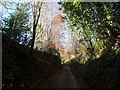
3
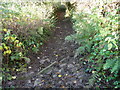
Hillside path above Mamhilad
Surfaced with densely packed stone hewed from the underlying bedrock. It has suffered some damage from motorbike scramblers and water in heavy rains but incorporates gullies and gutters to carry run-off away from the surfaced path. It has been put forward as a medieval packhorse route but also a Roman road. Apparently a Roman coin was found at Troed-y-rhiw Farm nearby.
Image: © Jeremy Bolwell
Taken: 18 Nov 2012
0.08 miles
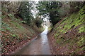
6
Lane above Mamhilad
Obviously a very old droveway down off the upland above.
Image: © Jeremy Bolwell
Taken: 18 Nov 2012
0.18 miles
7
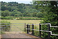
Fields west of canal bridge 61
A public footpath runs from the bridge across the field towards the gate.
Image: © M J Roscoe
Taken: 26 Jul 2018
0.19 miles
8
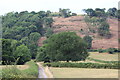
Hillside west of canal bridge 60
The tower on the skyline is The Folly.
Image: © M J Roscoe
Taken: 26 Jul 2018
0.23 miles
9
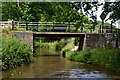
Bridge No. 61 on the Monmouthshire and Brecon Canal
Image: © David Martin
Taken: 18 Jul 2017
0.23 miles
10

Bridge 61, Monmouthshire & Brecon Canal
Modern bridge joining fields and carrying a public footpath. NCR 49 passes underneath.
Image: © M J Roscoe
Taken: 26 Jul 2018
0.23 miles